|
Penang Hills and Trails - Back from the Brink |
|||||||||||||||||||||||||||||||||||||||
|
This is one of a series of pages on walking the hills of Penang, click here for the index. This is a Grade 3 walk but needs care on the latter part as indicated. There is a sketch map at the bottom showing the route followed. Please visit my Penang buses page for information on accessing the starting point. Three days earlier we had attempted to walk the Anjung Indah ridge from north to south with pretty disastrous consequences, we had a most unpleasant descent to Jalan Tun Sardon and got home very late as a result. This was extremely strange as only a week earlier we had done the walk in the opposite direction with no problem at all. Today's walk was aimed at identifying where we had gone wrong and successfully completing the ridge as potentially it's one of the best ways out of Nanshan without any steep concrete down and a very convenient bus stop for a 502 down to Balik Pulau. Suffice to say eventually we did it, but not before we had to backtrack from an attempt to repeat what we had done wrong before as the key turn off is extremely easy to miss. We chose a completely different way up to Nanshan, of course, overall it makes a very good walk indeed. There is a detailed description of a similar climb up to Nanshan available in an earlier report if you find this account too concise. We walked out of Balik Pulau along the Air Itam road and turned right at the HT NH 4 88 electricity pole, Yuehong hardly needed to pose. The rules for the climb are twofold. Keep the houses on your right and keep left at every junction where there's a choice of concrete even if it means doubling back on yourself as part of a zig-zag. The key points are shown below.
It's one of our favourite climbs as it's shady in the morning for the most part but with some gaps which yield excellent views down to the sea and across to Bukit Elvira.
Eventually the path ends where you meet a concrete road. Going right and left here would avoid using it but we wanted the time saving option. That necessarily means going left and then right.
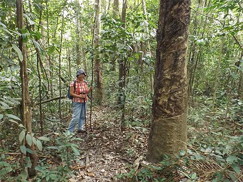
Where the road and path rejoin, we went straight ahead onto the concrete path and almost immediately took the (minor) right fork. The path climbed quite steeply pasts a small hut before levelling out at a pineapple plantation.
There's no longer any need to go right into the old rubber, we continued straight at the end and cut left through a short stretch of 'long grass' into the main rubber estate.
It's an easy climb up.
Where the rubber finished, I climbed up to check that as before there is a trail to the right into old rubber, the ferns ahead are bad news. The best way to describe the next section is 'undefined off piste' although it's hardly demanding.
It's wise soon to drop down a couple of levels and walk round the side of the small summit and then go down just to the right of the ridge. Yuehong was not impressed but I had already spotted the exit point ahead where someone had been attacking the trees just on the edge of the forest reserve.
This required a very minor detour before we emerged at a large, naturally fallen tree. We'd been here on the successful northbound Anjung Indah Ridge walk about a week earlier turning down towards Nibbinda.
Ahead was another tree down, this one was blocking the path up to the right which we had come down off the Bukit Relau ridge three days earlier. Of course, Yuehong knew where she was this time.
We had our lunch at the 'last farm', walked down beyond it and turned sharp right. Just after the two huts we went back into the jungle. If you haven't read the previous account then you probably wouldn't realise that I have recycled the next two pictures.
This, as they say, is where the story really begins... We climbed up to the small summit with the horizontal tree trunk. Now the hash paper goes off left here and that was of no use and I had wondered if there was a fourth trail we had missed but there was no possibility of this. So we turned right and went carefully along the ridge. There are several trees down and we easily clambered over them. Eventually we came to this one which turned out to be the critical one, looking at the picture data this was about 15 minutes after the summit.
Beyond it was a patch of prickly palms with no distinct trail. The hash paper 'helpfully' went slightly left and then started to descend, this did not look at all good, so we circled slightly right and found ourselves on a trail. I was quite happy, at least initially. I went back and recorded where we should have gone slightly right in the palms (see further on). We decided to photograph landmarks like this double tree but not long after we came to this boundary pole, bad news, the wrong yellow sign was just a few minutes ahead and we were making the same mistake(s) as before. I was even able to check the pictures which were still on the camera. Now there's a well known saying about people who don't learn from history being doomed to repeat it...
As we retraced our steps, we now knew that the real trail must have been on our left (right coming from Nanshan), but where was it? Eventually, I confess it was Yuehong who spotted it. For the record - and our own salvation when we come this way again - the two pictures below are critical. Firstly, just after the multiple 'small log down' above there is a rotten tree stump. We had started going left but now knew to go right, I dragged a branch to cover the left side. On the right side in the middle of the palms is the true 'way out', easy?
We'll test ourselves later in the holiday! Very soon we were seeing landmarks from the northbound transit which we had not seen going south last time. For Yuehong it was the ephemeral yellow berries, for me it was the pair of ancient rubber trees. Barring another very nasty 'accident' we felt we were now assured of a safe return to Anjung Indah.
We knew there was still quite a long stretch ahead but someone was 'happy'.
'Net' it had taken us just over an hour from Nanshan, in elapsed time rather longer. When we emerged from the forest, it was time for a clean up. This time we dodged the last steep descent and came down the open slope to the back of the restaurant, the part that most customers fortunately don't get to see. If going in the opposite direction, go round the side as shown into the open area and then take the sharp right hand open slope up to the forest entry, very soon you'll come to the plastic water tanks and the trail continues beyond.
Compared to straight walking, going to and fro in the middle of nowhere is more tiring, but today we had almost two hours before the 17.30 501 bus and that was more than enough to relax, refresh and do the shopping. We're off hiking in Thailand shortly, Yuehong wants a rest, I may do a controlled solo run in country she wouldn't contemplate.
|