|
Penang Hills and Trails - Da Ba Gong Explorer
Part 2 |
|||||||||||||||||||||||||||||||||||||||
|
This is one of a series of pages on walking the hills of Penang, click here for the index. This is a long Grade 3 walk with a significant Grade 4 section, not for the faint hearted! There is a sketch map at the bottom showing the route followed. Please visit my Penang buses page for information on accessing the starting point. The 501 bus service needed to get to Titi Kerawang had been withdrawn by September 2022. This makes this hike impractical for anyone without the use of a car. This account is linked from my Penang Peaks page which lists peaks over 400 metres as well as other places of interest and viewpoints. To find other hikes which visit this peak please check the maps of this are using this link. Above the Da Ba Gong temple there is one of Penang's 600 metre peaks. We have yet to get to it but the kicking off point will probably be the ridge described below. Earlier in the holiday we had spent a day exploring the trails above Titi Kerawang, we'd answered a few questions, but there still more than a few loose ends. Today we wanted to sort out the upper end of an alternative route to the higher area and a possible connection between the two main trails through very rough countryside. We succeeded! Currently we are trying to come to terms with our new neighbours who have decided to do a 'Ground Zero' reconstruction of their flat, something which has created an unbelievable amount of dust and noise in the last couple of months and is likely to continue for the rest of our stay in Penang. Coming from a civilised country they ought to have known better, but given the way Malaysia is, there's not a great deal we can do about it except give them hell when they appear to occupy it. Consequently, we are trying to do daily walks on weekdays and it's hard going given the demands of our average hike. We got off the regular 501 bus at the U bend below Titi Kerawang - it's obvious on the map - and turned left into the hills, there's what passes for a description in a previous walk. It was a clearer than average day, with a glorious view down towards Balik Pulau with the hills between Bukit Genting and Pulau Betong behind...
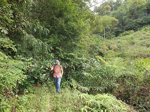
We passed a small group of surveyors at work, a new owner wanted to know just what he had bought, I just hope he doesn't put up gates and fences. When we came to the hut, we turned left up the hill where nutmeg was being harvested. The turn below is not obvious, we feel obliged to repeat this picture each time we come this way.
There's another zig-zag on this path before you come to a house where there is a welcome sign of investment in the future, those appear to be dozens of young durian trees.
The next zig-zag is on a grander scale as we met the road. First we turned right and then we turned left and finally we were on a new route.
Almost immediately after the house there was another junction. Behind the camera is probably access to the 'big house', but we needed to climb and at the next junction we went right, with the benefit of hindsight going straight would have saved much needed time.
Never mind, the view across to the Sungai Pinang hills and the National Park above Pantai Acheh was splendid - that's not a scratch on the sky, it's one of the local eagles in flight.
There was nothing wrong with the path, far from it, as it climbed steadily past an abandoned hut and into an open fruit orchard.
At the next junction, we turned right and the orchard continued.
Sadly the path ended at these water tanks and although we checked continuing to the right, ahead was classic secondary jungle, an impenetrable mass of small bushes fighting each other for space. We wanted to be some way to the left where the hilltop was known to be young rubber.
So back down we went to the junction and followed the other path round a horse shoe bend, below which we could see the end of the road. Oh dear! Unfortunately there was a rocky stream between us and the next rather less well maintained estate and after a couple of attempts, I found a way across which led into some overgrown bananas. The smile was more to do with not having to retreat a long way down rather than the prospect ahead.
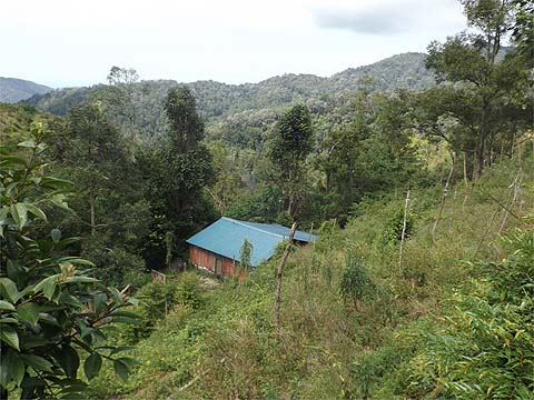
We were up to our knees in high quality green crap, but just above us was a house, you could miss it in the first picture but we soon scrambled up.
We could easily have got here from the normal main road, but that wasn't the point of the hike. Once he had got over the shock of our arrival (and put his clothes on), the Hakka occupant was more than friendly and happy to show us the way up into the rubber.
'Modest' doesn't do justice to his home, but imagine waking up every morning to a view like this...
We went straight up and fairly soon the familiar concrete path curved in and we had almost reached our immediate summit. We pressed on and joined the road which another day could have taken us down to Air Puteh eventually albeit with an overgrown section.
We had again avoided the dog farm and it was time for a little 'jungle bashing'. The theory was that the path down from the Da Ba Gong temple was not that far away behind the small hill ahead and we knew that there would be an abandoned vegetable farm (and its access path) even closer. So up we went along a wide path which seems to have been set up to gather and store water.
That was the easy bit.. There was clearly (!) no trail onwards, we cut through the long grass and down into an area where some cutting had taken place.
The immediate target was the stream, just a few steep minutes down. Here we found a tiny dam and from it ran a water pipe.
Following this (more or less) would do the trick nicely. There had been a path here once, but it was somewhat overgrown and largely blocked by fallen trees.
I was not keen to follow the actual stream as we had got ourselves wet and miserable doing similar elsewhere and so we tried the other side where at least it was a bit clearer. Down we went and somehow Yuehong's glasses stayed on and her rear end clean.
45 minutes after leaving the ridge, we came out by a near dried up water tank where some fish were struggling to survive. Yuehong spotted the path out on the other side of the stream and then we were out! It was not perhaps an experiment that I would bother to repeat but nevertheless satisfying.
Below us lay the abandoned house we had been to a month ago. When we got there, Yuehong picked most of the grass seeds out of her jeans. I then broke it to her that we had an hour and a half until the next 501 from Teluk Bahang. This did not go down at all well as it would mean rushing an attractive part of the walk... Anyway, as went along the exit path from the house, there was rather more than rustling in the weeds just next to it and something rushed past me, at first I assumed it was a monitor lizard as usual. Then in a moment of magic, just 10 metres in front of us emerged a wild boar, the first we have seen alive here. It stopped on the path, looked at us for two seconds and disappeared down the hill. We pressed on, the path is familiar and in very good condition now.
Yuehong especially would have liked to have taken it more easily, but when we got to the road at 16.15, there was a chance that the bus had yet to come. Two minutes later, it came round the corner and we were whisked off to Balik Pulau. Given our smelly state it was as well we didn't have to share it with many other passengers. We got our refreshments and filled the bags with fruit and headed for home. We had done two hard walks in two days, we needed a rest.
|