|
Penang Hills and Trails - Back Door to
Laksamana |
|||||||||||||||||||||||||||||||||||||||||||||||||||||||||||
|
This is one of a series of pages on walking the hills of Penang, click here for the index. This is a long, hard Grade 3/4 walk, none of the blocked path diversions is difficult but extreme care is needed with some of the rope work. This hike should not be attempted alone or by inexperienced jungle hikers. Those who do it, though, should find it a very satisfying experience There is a sketch map at the bottom showing the route followed. Click here for a list of the known PBA rain gauges. Please visit my Penang buses page for information on accessing the starting point. By October 2022 a metal fence had been erected just inside the starting point described here. I have not had the time to see how secure it is but it does suggest that PBA rain gauge readers would have to gup via the Tropical Fruit Farm instead. This account is linked from my Penang Peaks page which lists peaks over 400 metres as well as other places of interest and viewpoints. To find other hikes which visit this peak please check the maps of this are using this link. We're nearly half way through our annual visit to Penang and at last we're happy with our fitness. It was time to test it on Penang's toughest peak, Bukit Laksamana. Now last time round, I had joined a small group of hikers and gone up the conventional route from the Forest Park in Teluk Bahang. Today we would climb from near the Tropical Fruit Farm, to complete the route I had done in part (Rain Gauge Obsessional) and for this we were joined by Rexy Prakash Chacko a young Malaysian who also posts on hiking the hills in Penang. We met up in Teluk Bahang for the 07.50 501 bus and ominously it was raining. This is the starting point and for those readers unfamiliar with the meaning of such signs, it tells us we are on Route 6 (ie the round-the-island road, kilometre 43 and 59(0) metres - measured in a clockwise sense), the brightness is an extreme trick of the light. As I have described in the RGO link above, the initial climb is through abandoned rubber estate terraces close to the edge of the Tropical Fruit Farm. From a lack of a proper path, I guess the few people who come this way sneak through the farm early in the morning before it opens for business. The picture makes it look a lot more pleasant than it is.
This is the view from the top of the fruit farm, roughly 250 metres above sea level, starting up here saves about 200 metres of climbing. That's Bukit Batu Hitam on the left.
This is the gap we used, the route really is that close to the TFF. Higher up right at the top of the TFF there is a wall on the left and Rexy informed me that the three red flashes indicate the Forest Reserve boundary.
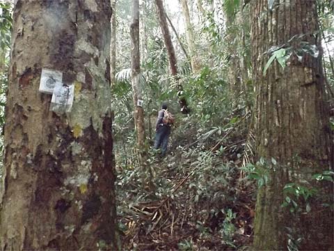
There are some blockages on the path but the canopy is high enough to make it easy to skirt them. Eventually we got to rain gauge 23 (RG23), last time I had been travelling very light and it had taken me not much more than half the time that it had today.
It was good walking in the damp gloom, the camera did very well considering there was no way to keep the lens dry. When we got to the yellow sign, I moved to high alert as I knew there was an area ahead which needed a side track investigation.
Just a couple of minutes later and easily missed, there was a ridge coming in from the right and the path takes a slight turn to the left following the continuing ridge. Having consulted topography maps I knew we were just a short distance from the top of the durian orchard on the north side of the Titi Kerawang valley (Laksamana Link). So I took Rexy off to explore - Yuehong had a day of indeterminate length ahead, it was wise for her to take a break now.. Rexy followed our progress digitally, but it was hardly necessary as there was obviously some kind of trail which had been used by the Penang Rain Forest Hash Challenge in 2012/4. To say their marking material was 'inappropriate' would be an understatement. A surprise along the way was a set of water pipes running across the ridge.
The ridge marks a boundary between two Forest Reserves judging from the tree markings so obviously the water abstraction was illegal although even I would have to admit that this was not the most egregious violation in Penang. The path started to descend and then to the right we could see what must have been a cleared area which we went across to.
Indeed, it was our target, the top of the durian estate which is actually planted with rubber and fruit trees high up but which are overgrown with ferns at the moment as the trees are too young to be harvested. It would not have been too difficult to get across to the west side here where the path up terminates. The hash trail would have continued down the east side to the final path up from the valley runs - as related by Peter van der Lans, this is totally overgrown at the moment. We looked at it recently and would concur!
It had taken us not quite 20 minutes to get here and Rexy informed me it was about 400 metres. So this is potentially a very handy link as an alternative start to the Bukit Laksamana climb avoiding the awkward stuff at the back of the TFF although obviously it would mean another 50 metres or so of climbing. We went back to Yuehong and continued slightly down before the climbing resumed but it wasn't steep at all. We came to the expected junction with the dead end to the right (as related by Peter van der Lans).
Quite soon we were at Rain Gauge 22 (RG22) with its view out over the Teluk Bahang Dam. Rexy informed we that we were at approximately 540 metres above sea level which was at the lower end of my guess on my previous visit here.
From here on, it was a virgin trail for me. The start is less than auspicious through the ferns. There was even another short downhill section, not indicated on my low resolution topography map. I had hoped for a gentle ascent from here, but obviously that was not going to be the case.
No one maintains this trail, nature has to be left to take its course. This small tree unfortunately fell along the track. At one point we could see the dreaded ferns ahead but fortunately the path skirted them, it actually passed to the left of the tree shown.
None of which caused any real delay, but woe betide anyone who wanders too far away from the path and cannot regain it, that's a seriously unpleasant sloping hillside full of ferns. At one point we seemed to have joined a second ridge with a trail running off right - that's Yuehong on our trail and we continued behind the camera. Now if I were to be coming down, then our trail would have been counter-intuitive and ahead (left) in the picture) would be the natural choice. At the moment, it's not a difficult choice as the other trail is clearly less used, but in a few years time when the effects of the Hash Challenges have worn off...
We were still some way off the summit and it was certainly not 100% climbing as usual on such ridges.
Up and over or go around, it didn't matter, there was nothing difficult.
Rexy spotted a small group of tiny orchids which he didn't recognise, the seeds would have lain dormant waiting for the right conditions to germinate. The hash markers just refuse to biodegrade and I assume they will be there for a long time yet.
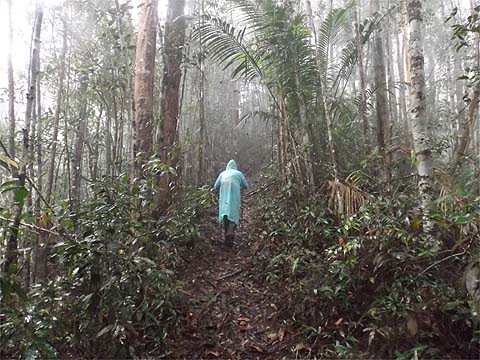
We were now well into the clouds, it's no fun hiking with a plastic raincoat but a total soaking would have been even less welcome. Finally we approached the 'summit' but it seemed to me that we had actually passed a slightly higher point just a couple of minutes earlier.
Now that was an extremely satisfying moment because even a year ago, the thought of Yuehong standing here (let alone smiling) would have been unthinkable. It was lunchtime and of course an equally large but different challenge lay ahead
The first rope is accompanied by concrete steps, a total luxury but the price to pay is another climb.
The camera lens was permanently covered in a thin layer of water, these pictures would not stand any enlargement, for the record this is Rain Gauge 12 (RG 12). Rexy realised that I had been serious about our speed (extremely slow) and he was in danger of being late for an evening appointment and turned back to go to the Forest Park at Teluk Bahang. Finally, we came to the main descent, Yuehong knew about it but only in the vaguest of terms.
Fortunately the rain had eased and the plastic raincoats could be packed away. Let the pictures speak for themselves, this was a serious 50 minute exercise with no room for error... I was left clutching three sticks and wielding the camera for most of the way, note how at one point the rope is so frayed as to be too dangerous to use.
Finally it was over, we'd been out for almost 6 hours and still had nearly 4 hours to go but Yuehong had not only been here before, she knew all the remaining paths well and none held any fears for her at all. In fact, all we had to do was pace ourselves carefully and it would be a thoroughly enjoyable second half of the hike. That's Rain Gauge 11 (RG 11).
We now used the cut off to Tiger Hill valley which saves a huge amount of time, it starts just a few metres after the rain gauge on the right. By and large it's a fair jungle trail to start with emerging at the junction shown where a flight of steps leads only to a water tank. The final section is a wide path although a tree was down across it.
We joined the Tiger Hill valley trail at 14.20 and headed south. Just as we left the cultivated area across a wooden bridge, we saw a newly laid path to the right. After some 200 metres there's a large area of jungle been cleared, maybe a couple of hectares. I've no idea if it is in one of the forest reserves but whatever the case it is totally inappropriate, there are large areas of the valley above which are currently idle.
We normally enjoy the next hour as the concrete path winds along the side of the hill climbing to the five way junction, but this time it soon started to rain gently initially and then with ever increasing intensity so that the path became a stream. It's very hot and sticky under the plastic raincoat too.
It eased off now and as it was 15.30 we had more than two hours to get down to Titi Kerawang. These blue signs are springing up all over the place now, I can't begin to guess what has prompted this. They relate to the Water Monitoring Division of the Penang State Government and this one informs the reader that this is the Sungai Pinang West Catchment Area of some 643 hectares. If it is meant to stop farmers allowing soil to wash in the streams along with all the chemicals they spray on their flowers, vegetables and fruit then they represent a complete waste of money, most of them won't be able to read the signs anyway. Anyway someone in Komtar has got a box ticked. By 16.00 we were at the Da Ba Gong temple which was as empty today as it had been crowded a week earlier. I confess after eight hours on the go, I was feeling a little weary. The walk on down is known to take around 80 minutes so we took a break and arrived at the main road some 5 minutes before the 501 bus would arrive if it was on time (ie 17.40), of course it was almost 18.00 when it showed up, but at least it seemed to have stopped raining.
It was raining again In Teluk Bahang but we got dropped by the Nasi Kandar next to the roundabout to collect my takeaway. Thankfully, Yuehong has finally accepted that normal people can't go on a walk like this without a proper breakfast first and some energy laden snacks along the way. She did extremely well and, apart from an extended virgin jungle bash, I think she is now capable of taking on anything which previously I might have reserved for my occasional private excursions.
|