|
Penang Hills and Trails - Bukit Cempedak |
|||||||||||||||||||||||||||||||||||||||||||||||||||||||||||||||||||||||||
|
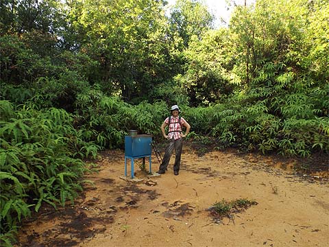
This is one of a series of pages on walking the hills of Penang, click here for the index. This is a long Grade 3 walk. I would again like to thank 'Larry Malay' for providing part of the route information based on his own explorations. There is a sketch map at the bottom showing the route followed. Click here for a list of the known PBA rain gauges. Please visit my Penang buses page for information on accessing the starting point. IMPORTANT By December 2023, the route from the Bayview Beach Hotel towards the Batu Ferringhi Reservoir past the 'Chin Farm' had been aggressively blocked by razor wire in the area where there is a gate by the water tank. There are also numerous signs stating "NO TRESPASSING - NOT A PUBLIC HIKING TRAIL" This will mean that there is no longer any access to / from any of these well known paths: 1. That to the Rimba at Teluk Bahang I do not know about current access through the main gate to the aqueduct above the former Holiday Inn. Much of this walk was previously reported under 'The Longest Day', that part has been updated, there are few significant changes. My few regular readers cannot help having been struck by the gradual emergence of a 'new Yuehong'. Since she discovered the charms of the hills in Penang just over four years ago, she has worked tirelessly and has now got herself into the kind of shape where she can tackle any walk which I can throw at her, with the proviso that it shouldn't contain al fresco hiking through pathless jungle. A year ago, most of the jungle tracks in the north and north-west of the island would have been off limits to her simply because they were too long and too steep for her capabilities, the basic trails themselves being fine. Now, in the last couple of months, she has been to Bukit Batu Itam in the National Park twice and Bukit Laksamana twice. It is in their nature that they have no option of short cuts or early exits. Apart from the option of a return to base, it's a question of 'all or nothing'. This time, we were making a start on the upper hills of the north coast above Tanjung Bunga and Batu Ferringhi, this was the first of three significant hikes I have planned. One minor advantage they possess is that the access points are readily accessible from home, there are no long bus journeys involved so we can take our time in the morning and still start before it gets too hot. In this case, we took a 101 bus to the Bayview Beach resort and headed up towards the Chin Farm and Batu Ferringhi dam below the Fettes aqueducts. This section, at least, is well known, behind Yuehong at the dam is the large fern patch which is a reminder of my disastrous end to the recent descent from Bukit Laksamana.
As we walked up the road, It was time for the first rain gauge of the day, RG 16, which is hidden on a side path that acts as a short cut to the start of the top aqueduct. Here is evidence that there might be life after death in the PBA rain gauge department. The battery here has moved since I photographed it nearly a year ago (insert) and I don't think they do earthquakes in Malaysia.
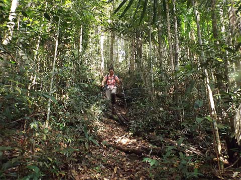
This is one of the very best forest climbs in Penang, of course it's quite steep but not exhaustingly so, with occasional near level stretches but no descents at all. The track is well defined and covered in leaf litter, there are no significant obstructions. The climb to RG 17 (480 asl) took some 75 minutes at our modest pace, throughout the day typically each section took about 25% longer than I had done, that reflected the fact that I knew I was going to be pressed for time and today we could afford to take things more comfortably.
Yuehong had taken my advice and had a bowl of shrimp wantons for breakfast but now she wisely topped it off with a reserve jam sandwich, it was too early for me to join in. 5 minutes later we were on our way again. I had heard from Peter that the ferns here were fierce, but someone had blasted a way through and as we went down I made a point of snapping off many of those growing closest to the path. In less than 10 minutes we were back in the forest and I guess we lost some 50 metres of height in the process.
Ahead was another 75 minutes of undulations, we would have to climb a net 100 metres from here. The pictures are in chronological order and give a good idea of what is involved. Experienced hikers would love this, any obstructions are entirely minor. The first section had had small pieces of the regular red and white plastic on the trees, where it came from I know not but it was no more. It had been replaced by the more pleasing pieces of blue string.
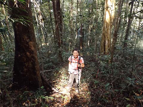
One final climb and we were at rain gauge 18 (RG 18, 540m asl) and I got a big surprise, the ferns which had covered it very recently had been entirely removed. Whether by hand or chemical I know not, equally there was no sign who had done it. Whatever the case, it was very welcome.
I was intrigued to see that the 'door' to the ridge leading to the rarely visited Bukit Batu Ferringhi had been left open behind where Yuehong is sitting. It's some way distant, at least 1km, and the condition of the ridge a complete unknown, but for at least the first 100-200 metres it held no terrors for me. I will return here another time but without Yuehong who declines participating in such adventures.
The next section was, perhaps, the least satisfactory of the whole day. It follow a ridge which gets very narrow in places and often drops away on either or both sides very steeply. Accordingly, it is very exposed and we had to negotiate a succession of blockages, some very recent where it was clear we were the first hikers to have been confronted by them, for the first one I had just removed a curtain of prickly ferns before I had crawled through. For the others, there were existing alternative routes out and back through the adjacent forest.
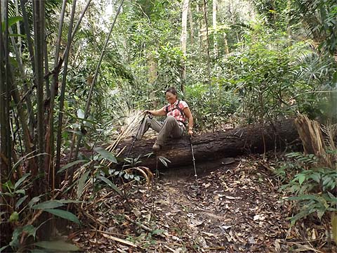
With an hour elapsed I was able to tell Yuehong this was the final climb before rain gauge 19 (RG 19, an estimated 580m asl). It's one of the prettiest of such locations and a great place for lunch with nearly all the climbing for the day completed. It was now 13.00 and we had been going for 4½ hours.
We said goodbye to the rain gauge and headed on, we were both tiring, especially me, as I had been out in the jungle above Titi Kerawang the day before. Fortunately it wasn't too much of a climb and only 20 minutes to the only junction of the day at 680 metres asl.
This was our highest point. To the left is Western Hill although with the security area it represents a dead end. If we had gone that way we would have been forced to soon turn left and go down towards the Botanical Gardens or Tanjung Bunga (masochists have the option of a link to The Crag on the main Penang Hill). I had been that way last time and in a few days time I plan to bring Yuehong here again from that side. It's a deceptively gentle start to the descent. I stopped to water a tree and found that Yuehong had raced ahead. When I caught up, it was at what she reognised as a 'photo opportunity'. Generally I don't mind blockages if the leaves are brown, this is a well known and well used trail and there was bound to be a suitable diversion.
I wasn't at all worried about this next blockage, I remembered it well because just afterwards the trail gets seriously steep, something we could have done with by now. Yuehong took an involuntary sit down and the large boulders were par for the course with this kind of gradient. It had taken us 75 minutes to cover this section but at least this time, I wouldn't be going back up.
It was time to dispatch another Tiger and finish another jam sandwich, we needed the 15 minute 'time out'. To be honest, the rest of the descent was nothing like so hard going although at times, it would have helped to have been an Olympic hurdler. Those fungi do their recycling work too slowly for our liking. Finally after 50 minutes we came to LYK's most famous sign.
Always the gentleman, I said "You go first while I record the action." However, I value my marriage so you'll have to make do with these two.
I didn't know how far we had to follow the 'river' but I could tell it wouldn't be too far as we could hear some young locals enjoying themselves in the rock pools above the crossing point. In fact it was just 5 minutes. I tried to fob off the last of the jam sandwiches on Yuehong but she was having none of it. In the end they became my dinner, I was that tired, but at least I had a final Tiger squirreled away. As for the other liquid we had exactly consumed the 5 litres of water I had carried up the climb to RG 17. I had stood here in December 2012, long before someone had dreamed up the need for these blue signs which have sprouted up everywhere and wondered what it would be like to go through the gate and start climbing. Now I knew... You can read more about that earlier visit to the Fettes aqueducts elsewhere on this site (it's actually #1 in these walks).
When we got back to the Bayview Beach we had been going for 9 hours, the air conditioning on the 101 bus did a great job drying us out and we felt much better as we trudged up the hill to home. We both slept well, we are enjoying our rest day, but tomorrow we'll be out again albeit with something a little easier with a nice Chinese makan in Sungai Pinang at the end of it. Roll on Thursday when we plan to head up to the Haunted House above Tanjung Bunga, by all accounts we'll finish that one knowing we have been on a climb. Just like the devotees who will going up to the temple above Waterfall Road as part of their Thaipusam vows at the same time, I know what I would prefer to be doing.
|