|
Penang Hills and Trails - Carla's Peak Part 3 |
|||||||||||||||||||||||||||||||||||||||||||||||||||
|
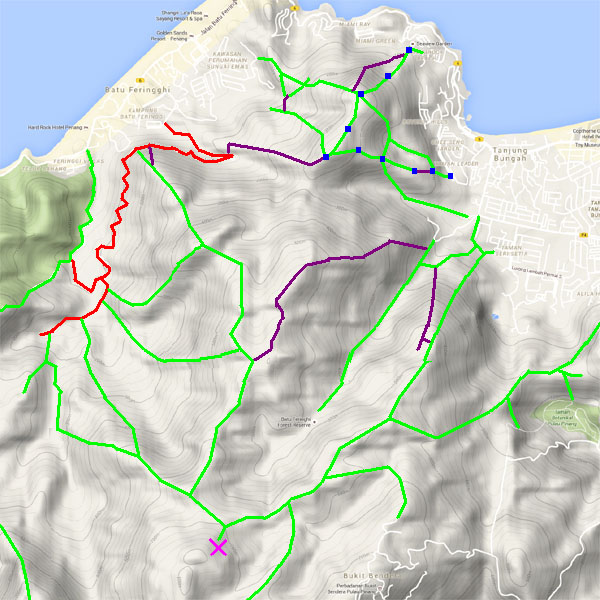
This is part of a series of pages on walking the hills of Penang. Click here for the index. This is a Grade 4 walk owing to the numbers of trees down on the final descent. There is a sketch map at the bottom showing the route followed. Click here for a list of the known PBA rain gauges. Please visit my Penang buses page for information on accessing the starting point. This account is linked from my Penang Peaks page which lists peaks over 400 metres as well as other places of interest and viewpoints. To find other hikes which visit this peak please check the maps of this area using this link. This report updates and replaces an earlier one posted several years ago. There are two other reports of visits made to this area about the same time which are worth reading to get a proper picture: The first two walks we had done over the long Christmas holiday weekend to avoid traffic chaos coming home from the south of the island. Now, a week later the New Year holiday weekend would bring even more chaos so we did a third walk in our home area. We did a fourth walk over Chinese New Year, we ended up in Batu Ferringhi and despite my professed principles we hopped in a taxi to avoid an inordinate wait for a bus. This hike officially starts in Jalan Pantai Batu above 'Shamrock Bay' behind the small Tua Pek Kong temple some way up. If you go in here you will find a wide track which leads up and joins the route described below. Since we live in Seaview Garden not far away we have a back door into the trail, this route is NOT available to the general public.
As we came up to the trail, we saw some other has paper heading off along the side of the hill, one to investigate another time. Then around 10 minutes after leaving home, we were retracing our steps from a few days earlier but going up instead of down.
In the meantime, we had seen a hash gathering in Jalan Low Yat and it seemed they had removed the 'BOMMY' paper and substituted their own - the Penang Hash House Harriets (the Ladies as we used to call them). Going up old rubber terraces is probably rather easier than going down.
The new hare seemed to have gone by the name of 'IMPOSTER'. There was originally an evenly graded ridge path but parts seemed to have fallen out of use making for the occasional 'technical' section between terraces.
Importantly, the trees here were not large and with just one exception they had been unaffected by the storm. When we go to the top of the old rubber after 30 minutes climbing, Yuehong's 'toy' suggested we were significantly more than half way up, that seemed right to me.
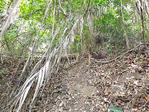
Beyond is a natural forest and we knew that there would be trees down on this section.
There was nothing difficult, but it did slow us down.
Finally after 20 minutes, the gradient eased and we were at the first of the two peaks. I spent some time hunting for the previously spotted rain gauge among the ferns but without success. That was not at all surprising really as if I had bothered to check my old report I would have discovered that it was on the other peak!
Now like 'BOMMY' before 'IMPOSTER' had been heading downhill, it's easy to tell these days when a hare staples paper to trees instead of scattering it on the ground. However, the new trail obviously had come in from the right here and I tended to assume that this was connected with the paper we had seen near the start...
We now set out to follow the ridge knowing that we had to be careful not to get lured down by the 'BOMMY' paper. We need not have worried, it had all been surgically removed. Very sensible, I suppose. At the point where the other trail went down, we could see the required path and very soon we found more hash paper on it - this time from the International Hash House Harriers, in fact we had seen some of their paper on the route from the peak described above. This is a great area for the hash and they do a great job keeping the paths open, but it does seem they could do with a little bit of imagination when it comes to selecting areas.
This is a lovely ridge path, it might almost pass for 'flat' and I recall just the one obstruction with a couple of trees down. The fungus was absolutely magnificent.
As we skipped over another trunk, we spotted familiar paper. Now my only conclusion had to be that 'BOMMY' had gone both up and down the trail from Shamrock Beach and had then added a loop via the second peak, the 4 way junction and the Sungai Siru valley, which meant, of course, that it was a 'lollipop run', so there was no 'missing link' to be found.
There was no sign of other paths at the second peak (not true as we discovered on Carla's Peak Part 4) and I should have looked for the rain gauge here, but it was time to turn sharp left and head downwards.
It was rather further down than I expected, initially there was no obvious ridge, but eventually it became clear we were on one and after a tiny dip we were at the 4 way junction. We had come up from the right as we were going and had gone down to the left. Today, we would use the path straight ahead which I had followed nearly 5 years ago. What could possibly go wrong? We'd been going just over two hours but it was definitely time for a Tiger.
We would follow the ridge all the way down to Tanjung Bunga and the path was clear with traces of rather older hash paper than we had been following.
At one point, there was string for the more sensitive souls and we made good progress.
The ridge was now a little wider but we still seemed to be on the path when I said to Yuehong "Have you seen any hash paper recently?". She hadn't either, but never mind, there were the red markers on trees to follow instead.
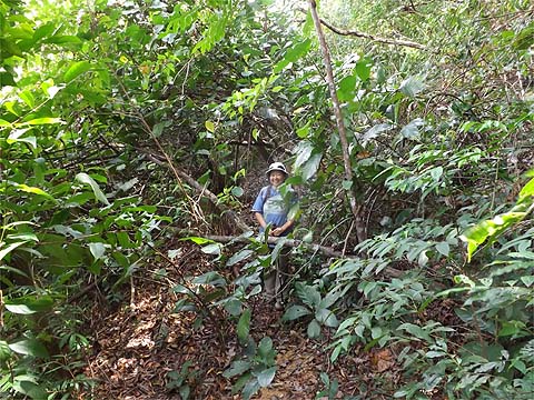
Then we found why the hash had given up on this ridge, there was a series of trees down right across it and, on either side, the slope was rather steeper.
Although we could see Taman Leader to the left, the right seemed more promising especially as there was some hash paper in evidence. We scrambled down and came to what might have been a rubber terrace once but looked more like a former wide path, it was likely to be the extension of the one we had followed before from the Sungai Siru dam.
Going down further did not look like a very good idea at all, We really needed to be going left but it looked obstructed. However, there was nothing that a pair of secateurs couldn't sort and we made our way along until we came to the remains of some water pipes. Clearly, this had been the route of the water abstracted from the Sungai Siru but it had been abandoned by the PBA (or its predecessor). It's clearly shown on old maps.
We came to a junction and it was clear that some enterprising farmer had decided that water left to run into the sea was water wasted. There was a tank here and plastic pipes running onwards and down. The path was too tempting to resist as an alternative to the route down we had used before. It went down to another junction, checking left it was a short distance away from that route. Hoping for an elegant solution we continued down coming eventually to a T junction. Right would presumably have taken us towards 'PBA corner' on Jalan Lembah Permai which wasn't really what we wanted at all. Left led us into a maze of small paths and eventually we found this abandoned building.
Just beyond it we had only to cross this small tree to find the steps down to Taman Leader. We had wasted the best part of an hour since we had come across the fallen trees above. As a result, I think it will be a while before we try this route again.
Never mind, we just had to get home and of course, Mavis was in the Seaview Garden car park so we had to take a 101 bus the short distance along the coast road. After a quick shower, we went out for a very early dinner and were back home again before the traffic had a chance to build up. There were no doubt fireworks going off all around to herald the New Year but we were long asleep by then.
|