|
Penang Hills and Trails - Back Door to Penang
Hill |
|||||||||||||||||||||||||||||||||||||||||||||||||||
|
This is one of a series of pages on walking the hills of
Penang, click here
for the index. This is a Grade 4 walk unsuitable for those without
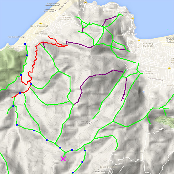
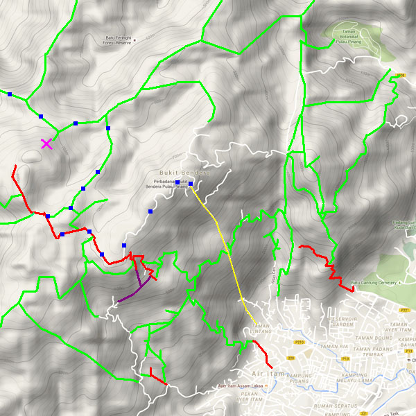
experience of off-piste hiking. There are two sketch map at the bottom showing the route followed. Click here
for a list of the known PBA rain gauges.
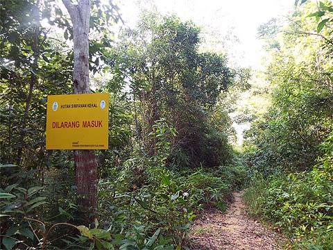
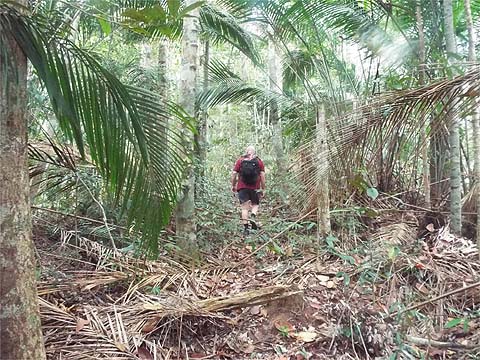
IMPORTANT By December 2023, the route from the Bayview Beach Hotel towards the Batu Ferringhi Reservoir past the 'Chin Farm' had been aggressively blocked by razor wire in the area where there is a gate by the water tank. There are also numerous signs stating "NO TRESPASSING - NOT A PUBLIC HIKING TRAIL" This will mean that there is no longer any access to / from any of these well known paths: 1. That to the Rimba at Teluk Bahang I do not know about current access through the main gate to the aqueduct above the former Holiday Inn. There are some splendid 'rain gauge paths' starting along the north coast of the island. However, since the route round the edge of the military base on Western Hill became unavailable, the only way to access the main Penang Hill has been to go via Bukit Laksamana or the trail behind 'The Crag' neither of which is a favourite of mine owing to their exceptionally steep nature. So naturally, my ears pricked up when friends Rexy and Peter told me that a route had been cut and marked between near Rain Gauge 7 and the ridge path above Rain Gauge 9. They successfully navigated it south to north in September and I took advantage of Yuehong's absence in Singapore to visit an old friend to hike along it southbound with Peter. Just who originated the route, we know not. The southern half utilises a path marked on older maps along a ridge leading to what is thought to have been the original site of Rain Gauge 7 which is now quite close to Summit Road. I had assumed that this path would have been abandoned after the move. Ideally we would have had two cars available so they could have been left at the opposite ends, but instead I caught a 101 bus the short distance along the coast road to the Bayview Beach Hotel and we started of at 08.30 towards the Batu Ferringhi Dam, the 'new' sign had yet to fall down, but it's as ineffective as all the others. The dam looked very attractive in the morning sun.
5 minutes later it was raining and the camera went away, I didn't want to have to repeat this walk because it had got wet as happened with my first hiking visit to The Crag. It was only a 'Penang shower' and by the time we got to the end of the Aqueduct it had stopped.
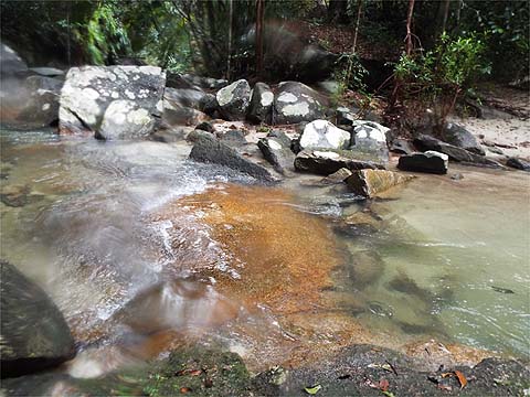
The stream as always was beautiful. It was running a little quicker than normal after the rain and we had to take care paddling across. One of Peter's shoes decided to go for a swim and an early finish to the day was only averted by a successful third attempt to grab it.
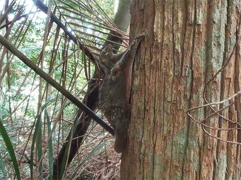
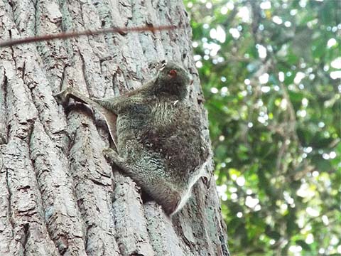
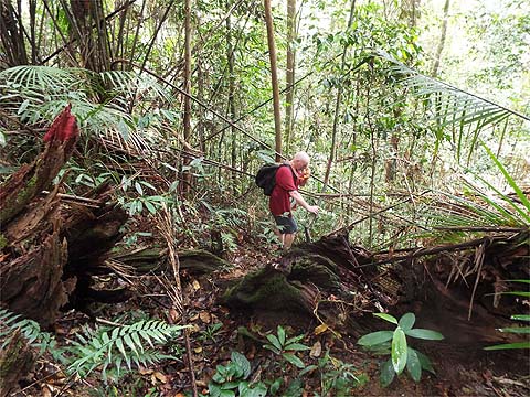
We were in no hurry, one hour had already elapsed by the time we started up the hill. Ahead was a long slog and we engaged a comfortable low gear. Peter stopped by a tree, at the base of which was one of those most unterrestial of creatures, a Colugo, also often called a Malayan Flying Lemur although it's not a true lemur as found in Madagascar. Not enjoying the limelight, it promptly hauled itself slowly up the bark and vanished into the canopy. It had been a totally enchanting encounter.
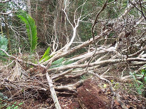
We had a brief conversation about making the most of life's unexpected opportunities and resumed. The sun put in its last appearance of the day and lit the forest perfectly. Less perfect were the trees which had come down in the Great Storm of November 2017 and were still a long way off rotting down.
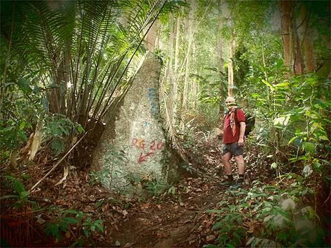
We arrived at Rain Gauge 20 an hour after we had crossed the stream. In view of our sedate pace, as we sipped our water and we mused as to whether it might have been relocated. This was merely an attempt to delay the inevitable resumed climb and sure enough there was soon a familiar old sign confirming that we had been forgetful as usual. My camera setting had slipped, it returned a not unpleasing effect which I have left as created.
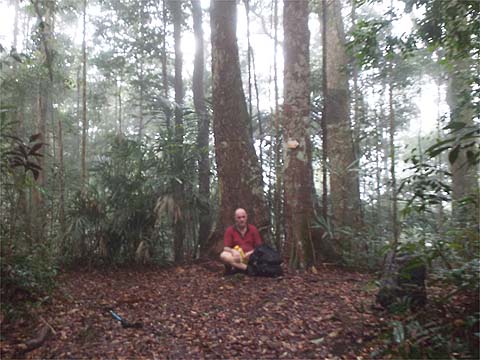
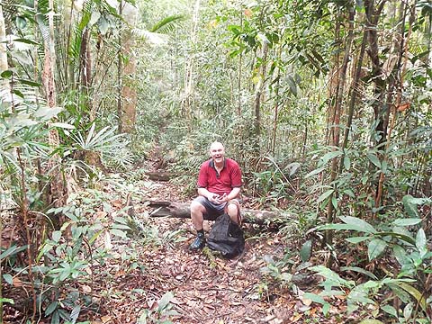
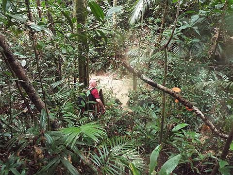
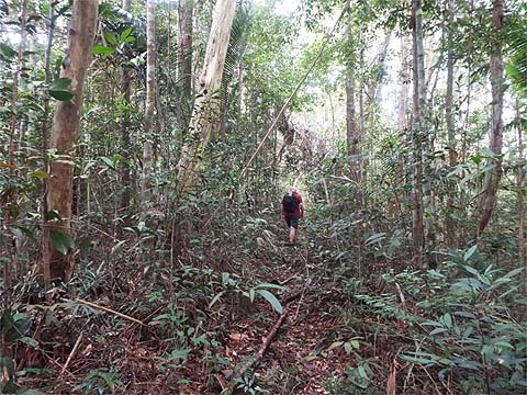
There were occasional flat stretches to relieve the monotony but conscious of a steep climb ahead through virgin jungle we continued to take our time. An hour up from RG 20, we came to the Bukit Cempedak junction and Peter's body language says it all. The special effect this time was provided not by the camera but by the clouds we were in which part misted up the lens.
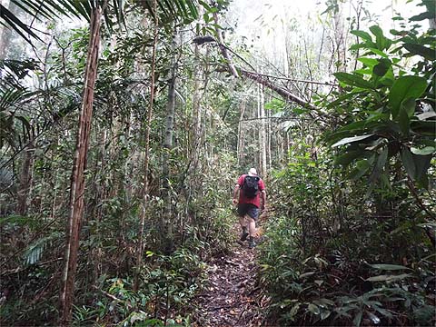
Others had been here too, there was a very little well rotted Hash paper and far too many small white plastic squares stapled to the trees. Given the good condition of the path and the lack of junctions, it would have represented willful negligence to get lost here. For various reasons, this was the first time I had been all the way up this path, but there was insufficient novelty to offset the monotony as we reached the Western Hill junction in a shade short of 4 hours (including our generous breaks).
We now had an hour or so of downhill in prospect. I groaned because while I relished the thought of a change I knew my knees would soon start to complain. Compared to the over exuberant members of the Rain Forest Hash, our hosts today contented themselves with just a single painted sign to direct us towards their 'grand oeuvre'.
99.9% of this red and white 'AWAS' plastic on the island is an intrusive waste of time, representing an arse covering exercise against those coming down the path looking at their so-called smart phone instead of where they are going. This set of trees, on the other hand, was so blatantly obvious as to need no sign at all. I was glad I had brought Yuehong here in our season before the Great Storm.
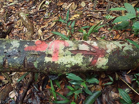
There are a series of what we call 'Moniot Stones' to pass, Peter said there were four on the section including one right near the junction. I thought Peter was laughing at me for being left so far behind, but in fact it was at his not so smart phone which had failed to record our route, no doubt because we were, as intended, too far from any mast to get a signal.
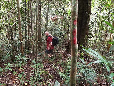
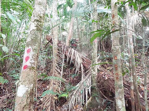
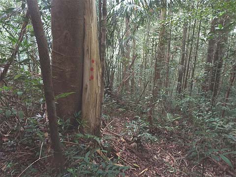
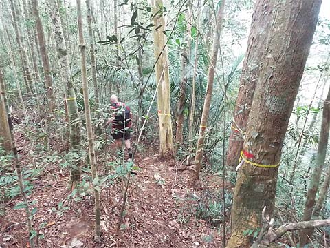
Now, for the time being that rotten tree half way across the path is a sufficient landmark, assisted by the painted red arrow, but necessarily it will be gone in a year or two although the 3 notches or 3 red spots on the trees may last a little longer. Let's just hope sufficient people come to use this new trail so as to make the 'entrance' clearer. More likely, the average would-be user will be a member of the jabbering classes and walk straight past and end up at Rain Gauge 9 or the Western Hill junction. For the record, it's rather closer to the former, midway between them. For the record too, I make it 5 sets of 'triple red' signs in my picture looking over Peter's shoulder towards our next section of the hike.
Spots to the left of them and spots to the right of them, just make sure there's always some in sight ahead. My rules like all such are there to be broken and this is a case where I was more than happy to see them so frequently. This is truly virgin jungle and the consequences of losing the trail could and probably would be most unpleasant.
We could soon hear running water below and the hillside got steeper and rather more slippery as we approached the valley bottom after some 20 minutes.
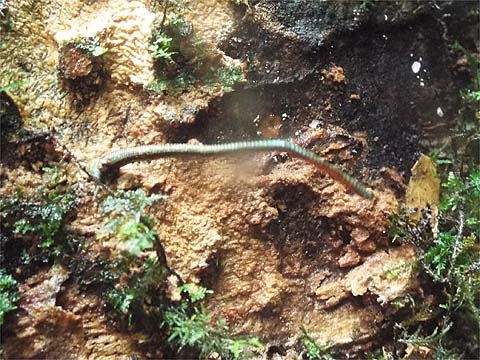
It's a charming spot indeed, the head waters of the large stream that runs into the Botanical Gardens. Peter ripped off his shoes to cool his feet but I declined, I wasn't sure I wanted to spend valuable energy getting them back on. I rested my bottom on a horizontal old trunk but soon moved when I realised I had company in quantity. Peter in his shorts was an easy target but generally he got the leeches off before they could do any damage.
We didn't want to be caught here should the rain return, not because we would be swept away but because there was a sharp slippery climb to get out. There were two kinds of markers each in sets of three. It seems the originals were 'notches' supplemented more recently with painted marks.
Of note was this tree, under the vine it seems to read 'Last Post', maybe the limit of one particular day's explorations and marking. The trail went slightly down for a while, I got the impression that coming in the opposite direction, the ridge (to our right) had been just missed, hardly surprising in the circumstances.
We soon started to climb again and now the trail became clearer but I would not yet have described it as 'a path'.
There are some things trailblazers cannot make allowances for. This tree with soil still on its roots had recently come down necessitating a small diversion. Eventually, about half an hour after we had left the stream, the trail took a slight right turn. This was more or less at the end of a gentle ridge, there was a painted arrow looking back. With hindsight, I think this would have been the end of the original Rain Gauge 7 path.
There was one more mega paint sign for people coming in the opposite direction. My memory is a little fuzzy but I think it was on our right which means we would have come from the direction labelled 'PRT', but don't rely on this if you come in the opposite direction!
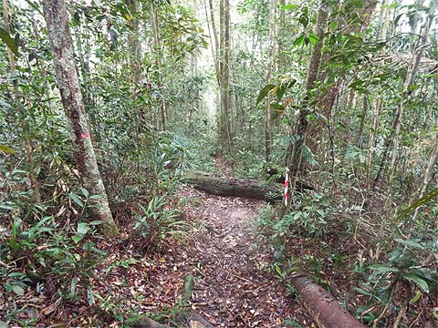
There was now no doubting that we were on a real path, it ran dead straight along a ridge, barely climbing. At just one point the ridge had collapsed to the right and we had to make a small signposted diversion. Otherwise, our new friends had obviously taken the view that there were better uses for their paint than unnecessary spots. Eventually, we came to a horizontal log in front of us. The obvious continuation was left, but when we went that way, the path immediately became less obvious and less used so I requested we go back to the tree.
Stepping across it there was indeed a path to the right and almost immediately another T junction where we turned left which meant we were going in roughly the same direction as before. We were in some kind of minor summit area and below us and in front would be Summit Road. Cue a further T junction, this one had a distinctive 'come hither' indication and we turned right without hesitation. Peter was now in familiar territory, there were many trees marked with yellow loops (a growth survey?). He also added that the path(s) to our left would have led to Rain Gauge 7, probably so, but that could wait for another visit.
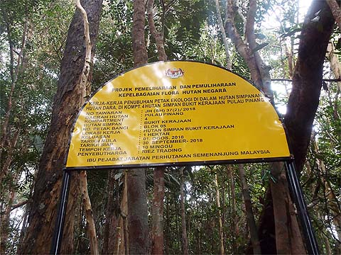
The sign made it clear that the project was a national one as opposed to a state one. I just hope they maintain their interest longer than the State Forestry Department which launches such things in a flurry of publicity and then quietly forgets about them altogether. That's not my problem though, we had come out at the Tiger Hill Pass and those cans of Tiger could be safely 'sampled'.
I could have done without the next couple of hours. Penang Hill was shrouded in cloud, walking down now was never going to be an option as we were tired and the concrete would have been slippery. We got about 100 metres before the rain started. I had my trusty Tesco plastic raincoat but Peter just got soaked. It eased as we reached the 'popular area' where the crowds were still milling around doing whatever they do once they have exhausted themselves walking about 50 metres from the railway station. There was more than a bit of a queue and several trains later, we just missed getting on one which had the great advantage that I could claim one of the seats right at the front reserved for those with 'special needs'. I didn't need to show my walking stick or prove my age, I don't think anyone else was greatly interested. We paid our inflated 'foreigner' price and walked down to the roundabout where we found some simple Chinese food and some cold Carlsberg. Peter discovered he had been giving a lift to at least one leech and when I felt an itch on my thigh, I went to the toilet and found I also had one on board. So ended a very special day for both of us, something that unfortunately most people on the island would totally fail to understand. Fortunately Rapid Penang's buses got me home rather more quickly than the journey from Tiger Hill, they were just a little cold for me in my damp state. Overall, we had been lucky with the rain, I spent the next day at home writing this report and there has been rather more rain than we experienced and if it is wet at sea level it's very wet at the top of the hill.... Will Yuehong ever come this way? That will be her decision because although she could probably cope with the climbing, the short downhill sections at the end of what would already have been a long day might be more than her bad knee could cope with. Definitely, she won't be going in the reverse direction to that described. A better bet might be to go up through the 'Haunted House' starting in Tanjung Bunga. I have a set of 'template' maps of different parts of the island which I use for reports, but, in this rare case, for this hike I need to use two! I can't justify the time to produce a new combined one.
|