|
Penang Hills and Trails - Bukit Gambir Explorer
5 |
|||||||||||||||||||||||||||||||||||||||||||||||||
|
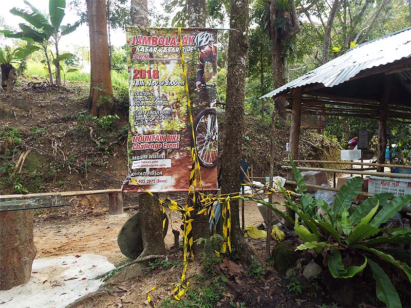
This is one of a series of pages on walking the hills of Penang, click here for the index. This is a medium length Grade 3 walk with a significant less straightforward section. There is a sketch map at the bottom showing the route followed. Please visit my Penang buses page for information on accessing the starting point. This account is linked from my Penang Peaks page which lists peaks over 400 metres as well as other places of interest and viewpoints. To find other hikes which visit this peak please check the maps of this are using this link. One of my hobby horses is to highlight the ignorance of organisers of outdoor events in Penang which by their nature should be as green as they come. The latest to attract my ire are those responsible for an event in the Sungai Ara area recently. We found a short section of today's hike festooned with black and yellow plastic, no doubt there is more, much more out there, given they covered 30km. I left this as a comment at the 541 biker's halt. These are overgrown children, no doubt their mothers still rush around clearing up the mess they leave at home and wipe their bottoms after they go to the toilet.
Anyway, credit where credit is due. When I lobbied the Penang Rain Forest Hash Challenge recently, they agreed to organise a tidy up after their event on December 15th 2018. Others please follow suit or I will continue to 'Name and Shame' you. In the early days of colonial South-East Asia it was fashionable to grow Uncara Gambir/Gambir in plantations (look it up!) and not surprisingly there are two Bukit Gambirs in Penang. The better known is between Paya Terubong and Gelugor and I wouldn't be seen dead there, it's been the subject of continuing egregious 'scalping' and development. The lesser known is further south above the Sungai Ara valley and because it's a minor peak and there were no known paths to the summit, I hadn't scaled it before today although I had done several hikes which got quite close. We entered the Sungai Ara valley by the Indian temple on Jalan Kenari (opposite SMK Sungai Ara) and parked by favourite pole OJK 52. All the way up to the next junction we found plastic tape abandoned after the recent mountain bike challenge, we gathered it up and you can see what we did with it above. I guess they had come down from the Blue House as we didn't see any more. A couple of guest workers were ferrying up building material to '541'.
Despite having to step aside to let them pass from time to time, the ascent was as fine as ever but there were reminders that some visitors forget their manners when they come this way.
The path through '541' had been almost totally destroyed by the mass of bikers that now come this way and we were pleased to see that from the junction upwards it had now been concreted which will stabilise things. Above the shelter, this purple flowered 'weed' was most attractive.
The next section up had also been given the much needed concrete treatment, but when we came to the next crest, Shock, Horror! What had once been a beautiful shady contour path through old rubber and developing secondary jungle was now a wide track with enough room for trucks to pass easily. It had always been one of the most relaxing strolls in this area, now it would be a sun trap...
I had always planned to turn right where we could see a half clear section, but it now became a matter of urgency. We saw some steps up to the top of the durian orchard on the right and a newly erected boundary marker suggested a trail upwards.
It wasn't wonderful but at some stage, people had obviously come up here regularly and we knew the main ridge was not a long climb away.
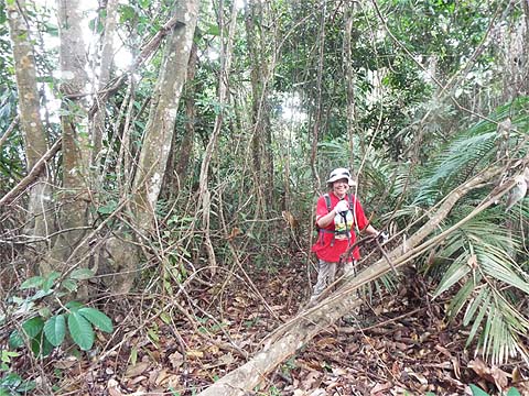
This was the only formal trail marker we saw and soon the secateurs came out. We could probably have bashed our way through the vines but a slow and comfortable ascent suited us right now .As the climb eased we found a small patch of ferns ahead, which we skirted to the left and found ourselves on the other side of the ridge where it was a lot clearer. We would probably have done better to stay on the wide track and turn up later, there's a point where the hillside looks 'accessible'. I'm not sure I would call it a path, but there was a customary route available, most likely it was used for occasional visits by wild boar hunters.
It wasn't exactly Yuehong's favourite hiking country, but we had agreed it was high time we again did something a little bit different and challenging, our island is a much smaller place than it appeared when we first started serious hiking 6 years ago and opportunities like this are very limited these days. It was never steep, but after a while, we came to a flat area which I guess was what passed for a summit.
Directly ahead was overgrown so we had to go to the left or the right. We chose the latter and immediately found evidence that this entire hill had been cleared at some stage. In fact, I would say that the rubber had last been tapped only a few years ago. As such it was easy to pick a rubber terrace to follow.
At one point we had to go down a few terraces on the right to get past a stand of bamboo and from here we could see that we were no great distance from the top of a durian orchard on the north side. Next we got 'pushed' to the left side of the ridge and again we could see a durian orchard, this time it had a wide cleared track round its top edge.
Conscious that we were approaching our self-imposed limit for exposure for Yuehong's knee, I said "There will be a path here down somewhere." and sure enough there was although it was rather steep. However, there were plenty of young rubber trees to hold on to and down we both went.
I always go first in these places and when I was just above the wide 'road' I grabbed what I thought was a tree root to let myself down only to end up on my back much to Yuehong's amusement. Of course, she then chose a much better spot as she is demonstrating. Should we ever come again, we would probably need an easier upward exit so we went round the top to our left and indeed there were possibilities.
It was out of season but it was obvious that once constructed, the track had not been greatly used, durians are rarely grown close to or on a ridge and it marked the limit of practical cultivation. The overgrown area above would also act as an informal reservoir.
Some parts of the track were clear and others less so, but we just followed it as it curved around and down into the bowl in the hills.
We came to a nice shady spot, we knew exactly where we were and it was perfect for a refreshment stop.
We had been here once before, the first time we had checked out Bukit Gambir It had not been a totally glorious exploration, we had come up to the far west end of the ridge from the north side but had no idea at which point so we had 'enjoyed' a long contour walk through the scrub below the ridge until we got here. The 'road' had deteriorated significantly at the top end in the meantime but the lower part was intact and we ambled out past the hut at the bottom of the valley.
The gates were wide open as before and we soon joined the main Bukit Papan road which was showing signs of 'stress' owing to lack of maintenance. The oil palms as always act as an easy to spot marker.
As at the other end '541' is now properly signposted and all we had to remember was to take the U-turn, the previously tempting route straight ahead was now heavily overgrown
This section has been 'car ready' for some time, but with a degree of subtlety and an eye for the environment. Yuehong was a short way ahead at the next bend and startled a couple of wild boar in the middle of the road, by the time I arrived all I got was the sound of their crashing off through the undergrowth. At the point where the new wide track starts, the path to the right down through the durians to the old rubber and Bayan Lepas was heavily overgrown.
Tracks like this look quite good until it starts to rain and the 'trash' dumped next to it starts to rot down. At one point my foot vanished into a mini quicksand, from experience the chances of the new owner completing his development are quite small. Presumably this barrier marks the limit of the plot.
Towards the north end, the hillside has been cleared above on the left and a track put in. I would guess that the plans include a suitable mansion. We didn't look to see how far up it goes but obviously it would offer a 'jump start' for getting to the top of Bukit Gambir. Just round the corner were the steps we had used to start our own ascent and which I had failed to photograph earlier.
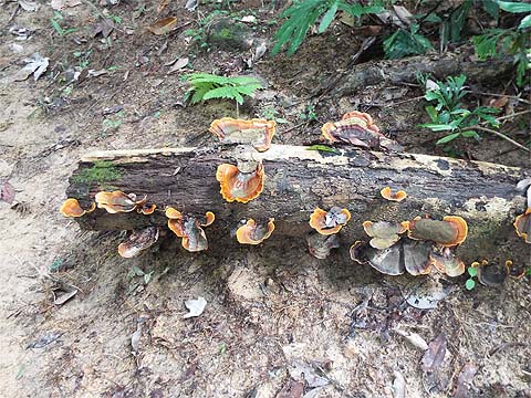
At '541' one development is a path running east into the old rubber. There was even an encouraging sign but no bikers will be coming this way just yet, in theory the 'Blue House' path is not too far away but it's at a much lower level. It turned out that this had all been done as part of demarcating the plot connected with the new road, there are pieces of red plastic and rubber trees numbered. We enjoyed the fungus and made our way back, the temptation had been too great and it meant that Yuehong's knee was later uncomfortable.
By now the sun was out and the orchards going down to the car and the hillside opposite were at their best.
This had been a very satisfying experience and all that remains now is to do the other half of the summit ridge (and the climb from the north). For the first, we'll definitely start from the Bayan Lepas side so as to avoid having to use the new 'road'.
|