|
Penang Hills and Trails - Malihom from the South |
|||||||||||||||||||||||||||||||||||||||||||||||||||
|
This is one of a series of pages on walking the hills of Penang, click here for the index. This is a medium length Grade 3 walk with significant less straightforward sections. There is a sketch map at the bottom showing the route followed. Please visit my Penang buses page for information on accessing the starting point. By January 2023, the path next to the Indian temple had a gate which is normally locked. The (new?) owner is not unfriendly but if he is not around then some enterprise will be needed. However, we found the hut at the top of the orchard unoccupied and the path which cuts back above it to the area that was cleared in 2019 is now totally overgrown. The result is that any hike to the top of the Sungai Ara valley or Malihom would be extremely challenging and that statement is made without knowing the condition of the cleared area and the col above it and the onward descent. This hike was carried out in February 2019. However, by November 2019, the orchard below the col at the west end of the Sungai Ara valley was completely overgrown again and the route through it indistinct. The path between it and the main orchard looked out-of-use. In particular the final section was such that you wouldn't spot it unless you knew where it was. As such, anyone looking to hike from the Indian temple to the Sungai Ara valley for the first time would need to exert extreme care. Coming the other way should not be as great a problem as long as you keep to the south side of the overgrown top orchard (added 26th November 2019).. Six years ago to the day, we had established that there was a way between the top of the Sungai Ara valley and the Teluk Kumbar to Bukit Genting road, but it wasn't a pretty route. Now we had been back on the east side checking and found a slightly different way up and not only the col cleared but also a large area below on the west side. This was a distinct indication that a return to the Indian temple, known as Vellaipala Arulmigu Sri Muneeswarar Devasthanam would be a good idea. Of course, now we had a car we would have to go back down that way again so I devised a circular walk which would do an ambitious climb I had long fancied. This would take us from the col above our starting point (red line) to the durian orchard near Malihom (orange line), this picture having been taken a few weeks ago from the upper slopes of Bukit Gambir.
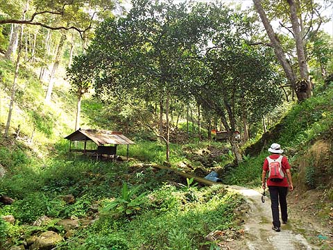
We parked up by the temple which is on a section of the old road now bypassed by a new viaduct. The path starts immediately to the right of the temple.
My memory of it was necessarily rusty but I was sure we just had to take the obvious route towards the col.
It's an old durian orchard and the trees are of some age, Management of the crop can't be easy, apart from keeping the underlying vegetation under control, I guess it's just a case of 'nanti durian' and collecting the fruits as they mature and fall. We soon got to the migrant workers' hut and noted that concrete paths now extended up the orchard - tempting but the ridge above would probably climb more quickly so they were unlikely to be of help, an assumption which turned out to be somewhat wrong.
I knew we had come down to the left of the shelter and we set off to look for a trail. My choice was this clear route.
Yuehong didn't fancy it and set off a few metres to the left. She was right, not for the first time. Parts of the climb were not unattractive but I was more than a little unenthusiastic about coming back down this way.
From my visit a couple of days earlier, I knew we would come to a large cleared patch and when we got there, it was time for a rethink! On the opposite side, it was much clearer and we made our way across.
In the corner was what looked suspiciously like a path and we would have to try that on our return. For now, we had to make our way through the debris. The remaining trees are all durians so simply burning off the trash was not really an option, I guess they will let nature take its course and then gather the woody bits and have a series of small fires.
We were quite grateful for the overcast conditions but the sun did make a brief appearance which highlighted the stunningly beautiful new tower block down in Teluk Kumbar. We had a narrow patch of old rubber to transit to the col.
Let's just say that this time I found a better way out at the top. When we got there, Yuehong took a big sniff and asked me to pluck a leaf; these days all I can smell is the chance of a beer. She was right, we had found 'Clove Corner', the greatest concentration of clove trees - I got to 8 before I gave up counting - that we have seen here. There was a ladder against one and they had definitely been consciously spared when the other trees here had been felled.
I had spotted this path when I had been up a few days before and I insisted we check it first. It led to a flight of stone steps...
... which led to a clearing which had once been occupied by a house. So back we went and started on Yuehong's preferred option through the bananas.
I always expect the first few metres to be the most overgrown and this time it was rather more and, as it was Yuehong's choice of route, she got the job of using her secateurs. Some time later, I suggested we tack sideways to where it was rather clearer.
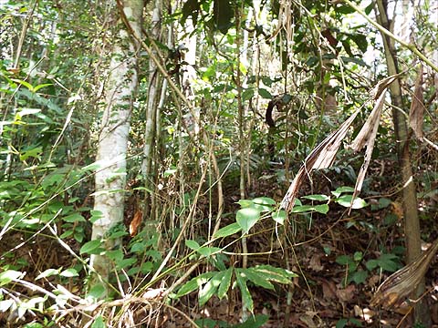
It wasn't perfect but it was rather better than what we had left behind. Soon we found ourselves looking down on the old house area. I hadn't really expected to find old rubber here and we had no idea how far upward it would go. There was no point in keeping the camera out, it was just asking for me to put down the secateurs and stick while doing up a shoelace and leave one behind as is my habit these days. We were following a vague ridge trail up the distinctly tired terraces. Groups of rubber trees were down in places, so there were several sideways diversions but we were always able to get back to the middle of the ridge.
Having 'wasted' 20 minutes at the beginning of the climb, it was only some 30 minutes before we could see the summit main ridge ahead. It was time to rehydrate.
There was a rough trail heading west but there was no thought to use it, such creatures are notoriously hard to follow down. Instead we went north-east along the ridge towards Malihom, passing these large rubber trees which gave some indication of just how long ago it was that the area was abandoned. Where the land in front of us started to go downwards, I knew we should turn right for a gentler descent.
There was a path of sorts and I guess wild boar hunters come here from time to time. We came out exactly where I had planned, the hut which is actually a large water tank for the orchard below. Our arrival from the forest exactly coincided with that of a Nepali worker on a motor bike who showed absolutely no surprise even though I'm sure he'd never seen hikers emerging here before. He soon vanished which meant I could strip down a bit to let my clothes dry out somewhat, it was time for bananas and a Tiger.
This looks too young a durian tree to have so many potential fruits, some thinning, natural and otherwise will be needed. Opposite was Bukit Gambir, the photo at the top was taken above the cleared area opposite which actually has a fair number of trees on it.
For me, the benefit of accessing the Sungai Ara valley from the west is that we don't have to go anywhere near that urban hell in front of Pulau Jerejak.
To complete our circuit, we had to go all the way down on the classic path and road. The initial orchard will look fine eventually but it'll be a good few years before the fruit trees are a decent size. The dogs at the Birds' Nest factory were as offensive as ever and I was glad to see that the gingers have finally been cut back below. As we passed the Thai temple, I went off to check another old house for rubber rollers and drew a blank. Yuehong went on ahead up past Fig Tree Hill Mark 2, so I have had to include an archive picture to show the turn off - OJK 110 is on the pole. Fortunately, it's very recent and she was wearing the same set of newly bought clothes. Shame about the sunglasses though!
I wouldn't have expected it to be too clear but obviously people do come up here. On the left, buried under leaves is the concrete path we used last time, we didn't bother to investigate it as today's route paralleled it quite closely.
There was just one large branch across the path before it changed from concrete / sand to stone steps.
However, it wasn't far to 'Clove Corner' and we carried on up and over into the strip of old rubber. After a rather unpleasant descent from near RG 27 to the Teluk Bahang Dam the day before, Yuehong's knee was gently complaining, necessitating a spell of reverse gear.
The cleared area was taken rather gingerly but we were cheered by the prospect of a proper path down and out. (As explained above, by January 2023, the next section was found to be completely overgrown, I would not recommend trying to use it unless you are very experience in the black arts of restoring lost paths.)
This was a brand new path, we would expect it to be concreted in due course, but for the present it is incomplete, we found a set of tools along it.
We came out just above the concrete path we had 'dismissed' earlier. It had taken less than half the time needed to get up to the cleared area and it means that there is now a more than comfortable route into the Sungai Ara valley from the west. (Remember this no longer applied by January 2023.)
We celebrated our success with a delicious steamed fish in Sungai Pinang with appropriate accompaniment and decided to declare a rest day after 8 consecutive hikes. We have two days of feasting in prospect and then intend to work it off with a further National Park hike which has a legendary degree of notoriety...
|