|
Penang Hills and Trails - Pantai Mas Challenge |
|||||||||||||||||||||||||||||||||||||||||||||||||||||||||||||||||||||||||||
|
This is part of a series of pages on walking the hills of Penang. Click here for the index. This is a Grade 4 walk. There is a sketch map at the bottom showing the route followed. Please visit my Penang buses page for information on accessing the starting point, but to be honest the timings do not work well! As of February 2023, the path between Pantai Mas and the junction near Bukit Batu Itam now sees much heavier traffic, not only is the route obvious throughout but it is lined by a wide variety of markers including the totally odious 'red and white' plastic. At Pantai Acheh, there is an alternative route marked round the back of the pig farm; I would still recommend using the route described below, it's shorter and less demanding. 'Pantai Mas' means 'golden beach', a name which as you will see owes a lot to someone's imagination. For hikers, Pantai Mas in Penang's National Park is the last frontier, the most remote and most inaccessible beach in Penang. While you can cheat and hire a boat, hikers get there from either Pantai Acheh or from Bukit Batu Itam. If you search for 'Pantai Mas Hike Penang' most likely you will have no more than 3 'hits' and 2 will refer to the same hike, the reports are by my friends Peter and Rexy:
The routes followed didn't sound wonderful to me, a waterfall in the dry season is no compensation for following a stream, which is somewhere beyond a last resort for me. Forest Ang in his classic book is scarcely encouraging, maybe he arranged a boat out. Consequently, beyond checking where the path down started, I didn't read them closely. I wanted an 'open book' to see if I could bring a new approach. Walks like this are not to be undertaken other than seriously, this was taken at the point ¾ of the way down when I realised life would be easier if I put the camera away and then 30 minutes later it was allowed out again.
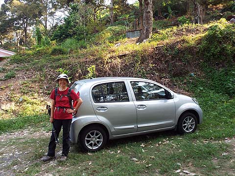
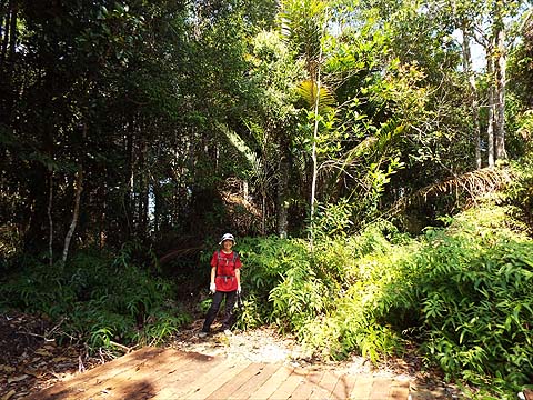
Firstly, though, here's a spot the difference question. The answer is the start and the finish of the walk some 8 hours later and Yuehong is still looking energetic.
If you are familiar with the route from Pantai Acheh to Bukit Batu Itam and on (towards Tekuk Kampi) to where the Pantai Mas path branches off, you can skip the first two hours. We left Pantai Acheh on our favourite path towards the 'Secret Garden' keeping left at the first two junctions.
We went up between the hut and the birds nest factory and headed into the orchard. We'd left just before 10.00 and it wasn't hot yet.
The upper part is quite shady and in around half an hour we were at the col, the first break point where we topped up with water.
We turned left up what is now a well worn path.
It emerged on a wider trail but to the right it is blocked almost immediately. This soon led to rain gauge 25 (RG 25).
We vanished into the ferns and enjoyed a brief flat section.
This area is inside the National Park and nature is left to take its course, either because it's the way it ought to be or those running the park never come to check it, probably both in this case.
It's very straightforward and there's a small dip before some serious climbing.
Near the top, I was glad to see the blockage because it told me we were approaching the second break point. For 3 years, I've had to divert around it but now the wood has rotted down sufficiently that you can just walk through. One of the reasons the path is clear is that 'Ultimate Trails of Penang' have it lined up for their October 2019 event.
Round here the trees seem very 'leggy' which is not necessarily a good tactic on a ridge. We knew we had reached the summit area when we entered the ferns.
Ahead was the campsite and it had taken rather less than 2 hours. I had noted that Peter and Rexy had taken 1½ hours, a measure of how much faster they walk than we do, but their combined age is only a little more than half ours.
This was the only comfortable place for a break all day and I stripped down so my clothes could dry out a bit in the sun and light breeze. This needed a little time, so I cracked open a Tiger. All too soon it was time to move on past the ridiculous catchment area sign. Just a couple of minutes on, we turned left at the junction - ahead leads to the Hokkien Cemetery at Teluk Bahang which would offer alternative access to here. Note that signs which were here earlier have now vanished for some reason.
As this is an official National Park path unlike the earlier one, hikers have to be protected so anything which varies significantly from the level now has a rope for reassurance. In this case, we went down and back up.
The ferns mask a long drop on the north side, so the rope is probably a good idea. We had some 450 metres to descend and being able to tick off the first 50 metres on a good path was a distinct bonus.
It's rather steep but level of usage is such that the leaf litter covers it. At the bottom is an information sign.
I remember thinking 'not far' when we first came this way in the opposite direction, but of course with that climb it was anything but. The path now climbs again to the point where a small ridge joins on the left side.
This was our path and such is its notoriety that some advisory branches have been placed across its entrance. Almost immediately Yuehong spotted that our 'friend' with the blue string had been here, we rate him (them?) as the most reliable of those who leave markers.
Not that markers were really needed to start with as the path went down and then along. Forest Ang talks of turning right at a junction with another path straight ahead, but that was the best part of 20 years ago and the junction has long gone and only the right hand path survives.
At a fallen tree the path was blocked and the 'blue string' went left. We soon decided this was not what we wanted, there was no longer an obvious path and instead we cut right back up to the ridge. Yuehong was not impressed when I vanished into the undergrowth at such an early stage in the descent.
However, I had actually got us back on the path and we found a tree festooned with markers, blue paint, red paint and three notches. Of the three, even though it was nothing like new, we found the first one to be the most reliable today.
The path was actually rather clearer and obvious than the pictures suggest. We were on a ridge with quite steep drops on either side so even when we had to divert off the path for an obstruction it was easy to regain it.
By the time we came to this final blue mark, we had been going down about 1½ hours, it was not far above where we came to the first of the boulders which got more than a slight mention in Forest Ang's account. From here on there seems to be no proper path and we used all our experience to choose a sensible route, always returning to the centre of the ridge as soon as possible. The last sign we saw of previous visitors was the F3 sign after some 2 hours of going down.
Yuehong was attracted to this rock, perhaps it reminded her of the nose that someone forgot to give her. It got to the point where the camera was a distinct hindrance and away it went. Despite appearances, there was nothing dangerous about our route and when I took the secateurs out as a precaution, I found I hardly used them.
We went round the side of a particularly large boulder and found that not only was it the last one, but the area in front was relatively clear and almost level. Yuehong rested her sticks and paid for this by almost immediately doing a two ankle trip on a vine. I came back to check and found her face down and uncomfortable. I persuaded her to roll over and take the strain off her knees and she soon recovered her composure.
She didn't even ask for a hand up and soon we came to this large stream. On the other side was some unspeakable vegetation. Now if I had paid some attention to what the others had done here I would not have turned right to try to get around it...
Half an hour later we were back here and did turn left and very soon we came to the first of many of these yellow signs.
We were very near the beach now, which was just a narrow strip of sand at best, reportedly covered at high tide. Veteran visitors talk of there being much more sand, I rather suspect it has been a victim of changing currents caused by the various reclamation projects on the other side of the island. In any case, the National Park authorities are now planting mangroves here which means the rest will soon disappear too. We went towards the south end of the beach past this large boulder with what looks to me like a strangler fig.
This was supposed to be our final view of the beach, except that I knew from a friend's recent experience at Teluk Kampi that it can be tricky to find the path out of such a place even if you arrived on it - he got out of the park after sunset having gone back to the entrance the 'long way round'. In our case, it was even trickier as we had never used the path, all I knew was that it would climb up. Now it was our turn to worry about the state of our underpants, because it was over 20 minutes of trial and error and returning to the beach before I finally spotted it. Everything was covered in leaves as it's the dry season and at the bottom there was only the slightest of hints of a possibility confirmed when it started to climb in earnest. The park signs, even when incomplete were a great help even if that was not what they were intended for.
It had been a long day and it was now 17.00 and were an indeterminate time and distance from Pantai Acheh. We were a little short of water and a 100 metre climb wasn't really welcome even if the trail was reasonably well marked.
Much of it was clear but at one point there was a scramble down and up which I could have done without.
The descent was gradual and we curved around Tanjung Gemuruh, encouraged by such marks which nevertheless seemed to disappear at critical times.
We saw the last of the National Park boundary signs and the path seemed to lose its head, first crossing these not very pleasant rocks.
Then it shot downhill where we found this pipe serving as a bridge across a small stream. Given what was just upstream, paddling here was not going to be a good idea.
On the other side, we found ourselves walking through Pantai Acheh's infamous giant pig farm. I'd never been here before and since I had heard that everything goes for export (allegedly to Singapore), I had assumed it would have been as high tech as Penang's other export industries. As you can see, things were not quite like that at all, it's almost enough to turn someone into a vegetarian. Searching the web later, it now seems that the effluent has a history of polluting the mangrove swamp between it and the sea.
As we walked into the kampung, we passed a vanload of workers from the Ministry of Health spraying as there has been a 100% surge in cases of mosquito borne dengue (1470) in the state in January 2019 compared to a year ago. While this side of the island had only four, one of them was in Pantai Acheh. We finished the last of our water and adjourned to the Seong Hooi to start on our proper rehydration. Our restaurant in Sungai Pinang was heaving as it always is in the evenings and that allowed an extra allocation of the same while we waited for our dinner. Stripping out the little 'extras' we had done pretty well and while I don't think we shall try it again this visit, I am reasonably sure we'll give it a second crack next time around. It was certainly of sufficient difficulty that we took a day off afterwards - this was our hike #86 for this visit and as you can imagine we are looking to raise that to the century mark by the time we return to the UK in 3 weeks time.
|