|
Penang Hills and Trails - Garden in the Sky |
|||||||||||||||||||||||||||
|
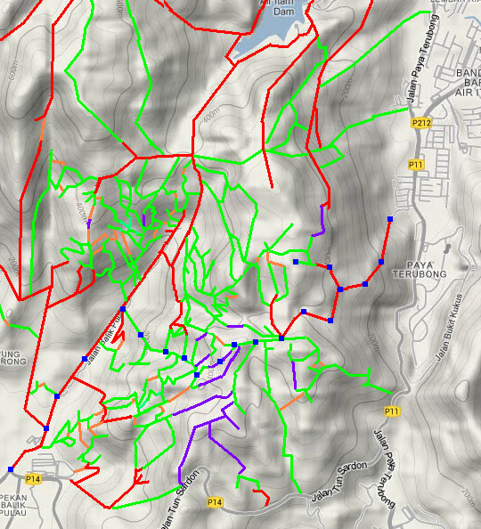
This is part of a series of pages on walking the hills of Penang. Click here for the index. There is a sketch map at the bottom showing the route followed. Please visit my Penang buses page for information on accessing the starting point. Parts of this trail are described on Forest Ang's website ( We started out in Paya Terubong (502, 201 or 202 bus, the 502 being by far the best option as it is the most direct service). We got off at the Nanshan eating place just before the former Lee Rubber Factory. The concrete path starts on the left in Jalan Orental 6 opposite. It's well graded but not well shaded and it was a good thing that the clouds were still hanging around from the rainstorm half an hour earlier. We were prepared for some good views from what was likely to be an open area, but the first was of the Paya Terubong flats which would be an automatic finalist in the competition to find the ugliest and least well presented flats in Penang. You've got to try really hard to create such a place and of course from then on it's just downhill all the way as you don't bother to maintain it. There are even worse looking places further up the valley, some never completed, but they are smaller and not so conspicuous. Turning around, we found the first of many shrines along the way, this was dedicated to the Seven Brothers.
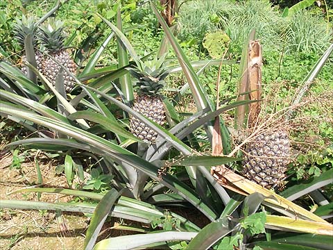
The whole area above Paya Terubong appears to have been mostly a rubber estate of which little remains. Further clearance continues and the area is becoming a giant fruit, vegetable and flower garden. At the moment, frankly much of it's a mess with low grade lemon grass occupying land with a few young trees, but no doubt eventually the area with trees won't look too bad from a distance. However, much virgin jungle, even on the hill tops will have been lost for ever, the water course will be polluted with agrochemicals and there will be serious erosion where flowers and vegetables are cultivated. Since this is not a water catchment area, the main use of the streams is to flush the rubbish out of the near open sewer that is the 'river' (Sungai Pinang) that emerges between George Town and Jelutong. So no problem, lah? I will leave the reader to guess whether any permission has been granted for 'change of use' and, if not, what are the chances that anything will be done about it. Still it makes for an interesting expedition with some cracking views. Here, first though are some of the local fruits, pineapple and rambutans lower down, sirsat (soursop) and pomelos higher up:
And so to the views. Firstly, the old Lee Rubber Factory which must surely soon be redeveloped for housing and will make the owners far more money than the original use ever did, followed by yet another shot of Paya Terubong and George Town:
Higher up, the second crossing beyond Pulau Jerejak and near the airport - under construction - comes into view over the top of the Relau Pass:
At the top of the first climb is a small temple to Tua Pek Kong (Nanshan Da Ba Gong). The walking sticks as offerings seem to be traditional in the hills, there are times when I feel it's getting to the stage when I need one too.
If you are repeating this walk, then you need to know that you should follow the road to the right behind the temple. At each of the next three junctions you should take the left fork, which will lead on to a trail that follows the contours before heading up a small valley with a stream on the right - although only a single concrete track it is wide enough for trucks and the tyre tracks show some had been up here recently. The first right fork is thought to have led to the Cheng Kon Sze temple, but we were told the path is no longer 'active', we checked this from the other end at a later date and found what we think was the original trail obstructed by the property of the Gotama Buddhist Forestry Hermitage. The second right fork led to several houses which seem to have been here for a while, one of them had this marvellous bush and there was a further small and barely used shrine:
Up the second right fork there were some splendid views north-east and south-east (second crossing above) and one of the 'guest workers' was harvesting the lemon grass. Meanwhile back on the main trail, the produce of the few remaining rubber trees will have a bit further to travel now:
Further up there is a rose garden; if we had roses like this back home, Yuehong would dig them up. Out here, I suppose for those who insist, they represent the best available in the climate. And of course yet another shrine, the purpose of which is lost on both of us, maybe it's begging forgiveness for despoiling the landscape. There again, probably not:
Immediately after, we arrived at the major junction at the col described by Forest Ang. He suggests taking the fork downhill out of sight to the right of Yuehong. This would not have been a good idea as we discovered on a later visit and we would recommend that as a much better continuation than what is described below. (The first path left, to the left of Yuehong in the picture, is now known to go up to more vegetable gardens and connect (with care) with an alternative climb from the top of the Relau Pass.) Instead encouraged by another 'Gast Arbeite' we followed the contour path slightly left. Shortly after, this we came to a shed across the path above a relatively recently cleared area. In the opposite direction we could see more cleared land and a section of jungle with the transmission masts on top of Bukit Penara. Connecting where we were with that point is a job that's on our list, it has been done quite recently but I suspect it will be hard going.
Beyond the track divided, we were directed to the left fork down where a new blue hut could be seen. We were told to take the jungle trail behind it for Balik Pulau but when we got there it rapidly became clear that this was the ridge path along the range - Balik Pulau would have been several hours away given that it is no longer well maintained. We had noticed that the 'Full Throttle Adventure Club' had laid a trail here recently and on the basis that if we didn't like the way they had carried on beyond the 'new blue hut' with a vertical ascent of cleared land, we might prefer the way they had arrived, we went back to the shed and took the other (right) fork behind it. This started as a good track (courtesy of trampling by the FTAC no doubt) but then became increasingly but not seriously overgrown once their trail had vanished back up towards the ridge path. We discussed returning to Paya Terubong, but Yuehong is made of stern stuff these days and we carried on carefully as the trail gently descended. Finally, as we spotted the first durian tree in the valley to our right just below us, we decided the trail was best left. It was not at all a bad decision, we slithered down for about 20 metres and found a few water pipes and almost immediately a good path.
It soon became concrete after which there was junction after junction after junction as we descended. Don't ask me to ever try to do this route in reverse! I know I could buy a GPS but it would spoil half the fun of discovery and distract from enjoying the surroundings. I have to say that although it wasn't very steep, it played merry hell with our bad knees.
There were compensations like the odd mangosteen and even durian but with our earlier diversions we were clearly not going to make the last 501 bus back to Teluk Bahang. There were more excellent views, this time over Balik Pulau to Pulau Betong:
Conscious that we would need to board a public bus, Yuehong removed some of the most obvious evidence of her 'adventure' but some parts would have to wait. Finally, we emerged on the Balik Pulau to Air Itam road and 'marched' into town.
We bought some rambutans and mangosteens (it being the weekend, the durians were overpriced), took the 502 bus to Komtar, grabbed a fast food 'Nasi Kandar' and then the 102 bus home. We slept very well!
|