|
Penang Hills and Trails - Tanjung Bunga to
The Crag |
|||||||||||||||||||||||||||||||||||||||||||||||||||||||||||||||||||
|
This is one of a series of pages on walking the hills of Penang, click here for the index. This is a tough Grade 4 walk. There is a sketch map at the bottom showing the route followed. Click here for a list of the known PBA rain gauges. Click here for our subsequent visit to The Crag Hotel as it is today. Please visit my Penang buses page for information on accessing the starting point. In a recent report, I explained how Yuehong and I 'needed' the path from rain gauge 9 (RG 9) to The Crag to complete our collection of significant paths on Penang. Unfortunately, we picked the wrong day for it (or any other walk for that matter), we suffered camera failure in the rain and now we had to do it again. This time though we declined to repeat the climb from the Botanical Gardens as we regard both the route with the 1251 steps and that from the lily ponds as unfit for purpose. Instead we chose a more user friendly ascent, namely that to the 'Haunted House'. If your interest is solely in the section from RG 9 to The Crag, you can skip to that point. Note also that at least one older report on the web has the Haunted House path passing to the east of Teik Quarry, this route passes to the west. With all the changes in this area, I do not know if that route is still available. Yuehong had asked for an early start and it wasn't yet 08.00 when we walked up to the PBA Pump House area at the corner of Jalan Lembah Permai in Tanjung Bunga. Instead of walking all the way round via the Tenby School. we headed up the side of the Deaf School on an excellent trail. This curved around, crossing a stream and ended at a small 'farm'. Fortunately there was a Y junction just before it and we walked back and took it until we came to the junction which marks the start of the path up to the Haunted house. You will note that the weather was as good this time as it had been poor when we climbed to The Crag before.
There are many more pictures in the earlier report of our climb to the Haunted House, I can't recycle them as that was a blue T-shirt day. Knowing the trail from before certainly seemed to make it easier and we steamed up to the ledge where I felt obliged to photograph Mount Erskine and Yuehong surrounded by rubbish.
In the short time since we first climbed here, it was noticeable how much of the egregious DAPpery had been removed by public spirited citizens, to the extent that all the plastic markers on the trees above had gone, along with the CDs and all that were left were the flags which seemed to be disintegrating, maybe by next time around they will be gone too. Politicians everywhere have the attention span of a cockroach which are their nearest related species, and here too having made their point, they seem to have lost interest and hopefully the path can be left as it should have been in the first place.
I'm still not sure about the paint scheme, but the traditional metal sign is welcome, although I wish Penangites could learn to spell 'Aqueduct' ,
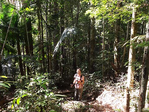
Now this next section is ridge path walking at its best, the pictures do scant justice to it. We had 30 minutes of relaxation and even the final short ascent to the man path was hardly onerous.
From here we were on my favourite ridge path in Penang for the third time in as many weeks.
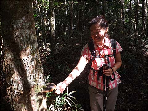
The sun nicely caught this fungal growth.
Up, along and down, nothing very steep and minimal obstructions, that's the way we like it, a reward for the earlier stiff climb..
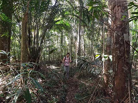
As is clear, it was a beautiful day, a greater contrast to our last visit here could not have been possible. The early start had paid off, at this time previously, we had just left the orchid house in the Botanical Gardens! It was time to relax, have a snack and restore our fluid balance. Ten minutes later we were on our way, this was #1 camera's first outing since its soaking and it seems to have been restored to good health. At first, the path was much the same as the main ridge path we had left although it will carry less traffic as few people will use both this and the path above RG 9. The slope was gentle and this made for good walking.
Gradually it became steeper and consequently, the path quality fell. At one point it seemed that regular users had performed some much needed maintenance where trees were down. This will have avoided spreading the damage zone outwards.
It was never difficult but we had to take care.
Ferns and slopes are always bad news but soon we reached the bottom of the valley. On our previous visit, the sound of the rain had drowned out the sound of the water passing below the boulders and I guess this route had been chosen for its relative ease of crossing, nevertheless it was a precarious feeling. Immediately afterwards, the unrelenting climb starts.
In an area which is never less than damp, dead trees soon get colonised with fungus. We had seen 'F3' painted large on far too many trees in the north of the island, I had always wondered why, now it seems we knew. I wish they would stick to this kind of sign which is far less intrusive. You NEVER see 'LYK' in bold one foot high letters.
In this case, the pictures do not lie, it's not much fun even if the path is in good condition considering everything. I guess its well deserved reputation keeps down the number of users. I spent most of the climb looking down on Yuehong, not that I am superior, it's just that I am expected to clear the spiders.
Then, of course, comes what I have dubbed 'The Wall'. We're fit enough for it not to be painful, but it's not scheduled for an early return, especially as I don't like the current Bukit Bendera (including the Hill Railway) one little bit and even the alternatives to the execrable Jeep Road have a lot of steep concrete.
I have included a fair number of pictures so no-one who might read this and decides to come this way can't complain afterwards, but the short final upper section doesn't need ropes.
The end comes as a merciful surprise, we recommend turning right along the drain and going up to the left of the boulder. During and after the filming of 'Indian Summers'. some attempt was made to restrict access, but that was long ago and the best way out is to pass through a couple of metres of long grass behind where Yuehong is sitting.
We made an extended visit to what is left of The Crag, then walked up to the top of the hill and along the Summit Road as I 'needed' rain gauge 7 (RG 7). Along the way we passed RG 8 (outside Richmond) and RG 6.
Quite how Peter van der Lans came to stumble on RG 7 which is actually up a cul-de-sac quite close to the Summit Road and not some way into the jungle as marked on my maps, I don't know, but I am eternally grateful that he spared me the effort of blundering around there. The turn off is on the right, some way beyond Southview and the end of Moniot Road.
Yuehong hadn't eaten enough breakfast and sat that one out. I am always reluctant to use the train up or down, but it made sense today. We got a train which left almost as soon as we got to the station and the 204 and 101 buses onwards connected perfectly so we were at our regular Indian restaurant at the far end of Tanjung Tokong by 17.00. Yuehong was in 'recovery mode' so I was forced to drink three cans of Tiger before she felt able to tackle the walk up the hill to get home. I still have RG 1 and RG 5 to visit. The former is at the reservoir above the Hill Railway Road roundabout, but the PBA is uncooperative. I don't think my frequent criticism of them here has anything to do with it, more liekly it's something they inherited from their British predecessor. RG 5 is shown on maps as sharing Western Hill with the Malaysian military. I guess when I want a free flight back to the UK, that will be the time to go and look for it.
Of course, we aren't going to hang up our walking sticks but any future voyages of discovery will probably be 'pathless' or on routes where a path has long ago perished. Most of our hikes will be like meeting old friends after a long time, as happened last Wednesday when three of us who worked together at USM 40 years ago met up again, the others are Roger Jewsbury and Penangite Sam Teng Wah.
|