|
Penang Hills and Trails - Bukit Lang, Bukit
Timah and the
Haunted House |
|||||||||||||||||||||||||||||||||||||||||||||||||||||||||||
|
This is one of a series of pages on walking the hills of Penang, click here for the index. This is a long Grade 3 walk. There is a sketch map at the bottom showing the route followed. Click here for a list of the known PBA rain gauges. Please visit my Penang buses page for information on accessing the starting point. IMPORTANT By December 2023, the route from the Bayview Beach Hotel towards the Batu Ferringhi Reservoir past the 'Chin Farm' had been aggressively blocked by razor wire in the area where there is a gate by the water tank. There are also numerous signs stating "NO TRESPASSING - NOT A PUBLIC HIKING TRAIL" This will mean that there is no longer any access to / from any of these well known paths: 1. That to the Rimba at Teluk Bahang I do not know about current access through the main gate to the aqueduct above the former Holiday Inn. This account is linked from my Penang Peaks page which lists peaks over 400 metres as well as other places of interest and viewpoints. To find other hikes which visit this peak please check the maps of this are using this link. Just four days earlier, the 'new Yuehong' had faced another great challenge when we went up Bukit Cempedak, today it would be a different ascent but in the absence of any alternative, the descent would be a repeat of that. I had long known of what used to be called the Teik Quarry path from Tanjung Bunga but its reported length and steepness put it out of Yuehong's range and, since we prefer to hike together, I had yet to do it. More recently the path has been adopted by what has been termed Penang's DAPocracy, a term which describes how this state government has become a bunch of control freaks just like their predecessors. Someone who shall remain nameless described them as just like the previous bunch but more efficient, by which he meant that under them the pace of development had stepped up. I've never met any of them fortunately, although a senior member is living in our block temporarily while his splendid mansion nearby is being refurbished. This 'man of the people' has three cars for his family and his wife has made herself very popular with her habit of parking one of them at random in our car park where every apartment has an allocated space. This hike coincided with the annual Thaipusam event which the DAPocracy has attempted to hijack by engineering a second (golden chariot) to try to supplant the long standing silver one, both of which will have travelled out (and back) from the heart of the heritage area in George Town to the temple near the Botanical Gardens. Rexy Prakash Chacko has described the first part of this walk on his blog - https://rexymizrah.wordpress.com/2016/09/18/hike-bukit-zizai-trail/ - this includes a map of how to get to the start. As it happens, the 104 bus now turns from Jalan Lembah Permai into Jalan Lembah Permai 1 which runs past the Tenby International School which is very helpful. Coming from Tanjung Bunga bus station, we planned to get off the bus near where it turns left for TAR College, turn right and walk to the end of the road past the new Chinese temple (I assume like the Floating Mosque this is an upgrade of the original in a different location, paid for by developers). This is where the trail now starts, the original one having been clinically severed by the local developer's hillside clearance. Unfortunately, these buses go rather infrequently and we saw one leave just as we arrived in Tanjung Bunga so we walked - as expected we didn't see the next one arrive before we turned off. (For an alternative more attractive approach to this point from the PBA on Jalan Lembah Permai, please read the start of this later report.) Note also that at least one older report on the web has the Haunted House path passing to the east of Teik Quarry, this route passes to the west. With all the changes in this area, I do not know if that route is still available.
Shortly after the signs show to turn left, the path ahead we later found basically curves round to beside the gate of the PBA establishment at the corner of Jalan Lemba Permai. It really is a most inauspicious start as it crawls along next to the developer's metal fence. It was a public holiday for Thaipusam so there were a few other walkers out. Fortunately, things soon improve:
It's a path which has had a fairly recent makeover and I'm sure whoever did it was well meaning, but there are issues with it already and others I can see coming if it becomes popular as is obviously intended. The wooden steps are a good idea but will need a lot of maintenance, it's far too wide and already a tree is down. This area is a former rubber estate, laid out into terraces and that makes for a series of steep steps which will be difficult to maintain as later pictures show.
Where the path levels out, it's an excellent 'jungle trail' but the decorations are best described as misguided and inappropriate.
The viewing platform and resting point are a great idea, it's just a shame about what you can see below. The 'Living Waters' I suspect are a small stream.
Parts of the path are already showing the strain after little more than a year of its reopening. What will it look like in 5 years time?
The less steep parts are indeed excellent.
At one point all the soil has vanished and bare rock is showing, the trail now runs to the side but this soil will soon wash away too. You don't have to be a trained ecologist to work out what is going to happen in the other two places shown. Fortunately, the gradient eased and we left the relatively open area.
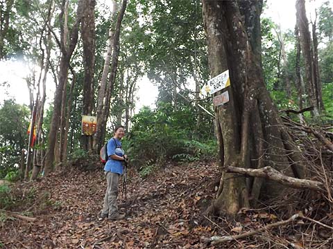
We passed on 'Bolster Rock' as we had a long day ahead and climbed up to the Haunted House (on what used to be called Bukit Timah), it had taken us 90 minutes, roughly as I had expected.
This is the house, the most important repair was to the roof. We didn't go inside as we really didn't fancy taking our boots off. At this stage, Yuehong was in desperate need of a pair of Good Samaritans because along the way she had managed to drop her hat, we've had the pair for our hiking for over 5 years and losing it would have been a bad omen. Fortunately, my brain was working well even after the climb and as our fellow hikers were going straight back down, I asked them to look out for it. I'm pleased to say that when we got home, there was an email saying they had found it. Thanks a million!
The trail continues behind the house, the sign has a menu of possible destinations including the Botanical Gardens, The Crag and, our one, Batu Ferringhi. Fortunately, the DAPpery soon finished and we found ourselves on a classic jungle ridge path.
Quite soon the path started to climb and Yuehong found out what the gods think of those who who lose their hats, I knew from the height of the Haunted House that it would not be a long 'up'.
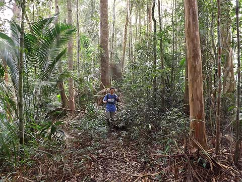
It had taken just 25 minutes to connect with the path from the Botanical Gardens. With the Thaipusam antics today, it would have been madness to turn left so we turned right towards rain gauge 9 (RG 9). I knew what to expect having come down here in March 2016, but it was Yuehong's first time on what is probably Penang's best jungle ridge path. Of course, it wasn't perfect, nature never is, but for half an hour we could relax and stride along as the path went gently up and down.
For some reason I could not fathom, Yuehong wasn't keen on 'refreshments' in the open at rain gauge 9, preferring the company of mosquitoes in the shade nearby. Most hikers seem to leave this ridge here to go off to The Crag, but that one will be our next venture along here. For now it was simply 'full steam ahead'.
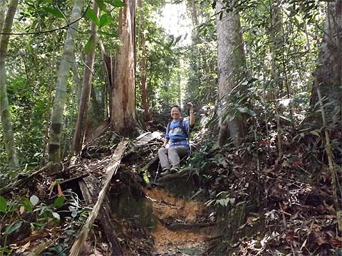
Someone had christened her the 'iron lady'. Now this path is littered with phallic symbols, old survey stones so perhaps for a lady her positioning was not well advised... Who cares, just be a little more careful next time. All good things come to an end and after 50 minutes we were rapidly approaching our third major junction of the day.
A year ago, this sight would have been unthinkable, here was Yuehong at the end of a climb of nearly 700 metres, fresh, smiling and ready for more. Brilliant.
First though, I had a hankering to see what would happen if I turned left. Actually I knew the answer and people who have ignored the sign have found they get the wrong kind of warm welcome. The days when you could sneak round the fence are long gone, I understand they have CCTV monitoring, the area is very sensitive since MH 370 passed almost straight over the top of the Western Hill radar station without anyone on duty noticing.
It was time for lunch, we had done far better time wise than I had expected and had plenty of time in hand. As we headed on, I think Yuehong had spotted another funny shaped object. I just added another of my favourite ground gingers to my collection.
This was one of the shorter sections of the day, again just 25 minutes.
While all jungle paths have a delightful sameness, I find the junctions distinctive but I'm not sure that Yuehong recognised that we had been here just 4 days earlier. Yuehong's decision to go for our 'away strip' meant that my plan to recycle the previous pictures had died a death. I have included a very few new ones, it you would like to see the descent in more detail, please check out the Bukit Cempedak report. Suffice to say Yuehong managed to spring her usual 'sit down' on me albeit much earlier than the last time. On the way down, I walked right past what I now know was a (Malayan) blue coral snake, Yuehong spotted it. It was probably just as well that it immediately slithered away from her as it's extremely venomous.
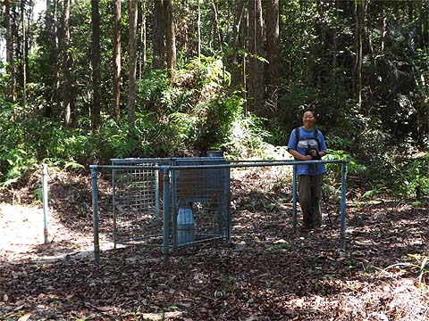
I was on a different Tiger cycle today and was ahead of Yuehong when we got to the twin trees and we found that this time we got to rain gauge 20 (RG 20) in just an hour from the junction. My lovely wife had so enjoyed the previous expedition here that she had offered to carry four cans of amber liquid this time; who was I to turn down such an offer? In case you think I am abusing her kind nature, I ought to point out that I had started out with some 5 litres of water which was actually our main supply of liquid.
We flew down the last section and I was sufficiently confident to walk along the tree across the river, sadly for posterity, I had our only camera with me. What Yuehong thought of it, I dare not think, she was far more sensible.
We hit the Bayview Beach Resort 8 hours after leaving the temple, with our breaks that was about 7 hours net. It's another absolutely top notch jungle walk and Yuehong is totally hooked on this kind of new experience. Sadly, there's just one new route left for her, that's the one from the Botanical Gardens up to rain gauge 9 and across to The Crag. However, that will have to wait for a while as we have a couple of Hakka makans booked, after which we have a car for a week which will be used for 'south of the island' exploring and a trip to Ipoh. We've visitors when we come back too.
|