|
Penang Hills and Trails - Bukit Batu Ferringhi
Rerun |
|||||||||||||||||||||||||||||||||||||||||||||
|
This is one of a series of pages on walking the hills of
Penang, click here
for the index. This is a Grade 4 walk unsuitable for those without
experience of off-piste hiking. There is a
sketch map at the bottom showing the route followed. Click here
for a list of the known PBA rain gauges.
Please visit my Penang buses page for information on accessing the starting point. IMPORTANT By December 2023, the route from the Bayview Beach Hotel towards the Batu Ferringhi Reservoir past the 'Chin Farm' had been aggressively blocked by razor wire in the area where there is a gate by the water tank. There are also numerous signs stating "NO TRESPASSING - NOT A PUBLIC HIKING TRAIL" This will mean that there is no longer any access to / from any of these well known paths: 1. That to the Rimba at Teluk Bahang I do not know about current access through the main gate to the aqueduct above the former Holiday Inn. The hills of northern Penang rise steeply from sea level. Like their southern counterparts, most once once had rubber planted up to a height of roughly 200 metres (with the notable exception of what is now the National Park), although all was abandoned many years ago and the only traces left in places are terraces and very old rubber trees. From a distance these former estates look like 'jungle' and they are slowly reverting to that state. With the exception of the cultivated east face of Penang Hill, most of the hills are now either Forest Reserves and / or catchment areas and are afforded a degree of official protection. In practice, unlike in the southern half, enforcement is rarely needed and despite the warning notices, apart from the military area of Western Hill, hikers are free to come and go. The nature of the hills is such that they are made up of a series of ridges and historically paths were established along them for water conservancy purposes, particularly the establishment of rain gauges; today while the rain gauges are effectively defunct, most paths survive for recreational purposes. To access them, steep paths, also following inclined ridges have been established, some of these have rain gauges along them and some have become degraded owing to overuse. There are very few paths between ridges, the better known examples are those along the Tiger Hill valley and connecting rain gauge 9 (RG 9) with the former Crag Hotel. Some time back, looking at a (topographical) map of Penang, I noticed that two peaks and associated ridges stood out as being almost unreported by hikers, namely Bukit Pulau Betong and Bukit Batu Ferringhi. The former (smaller and in the south) I visited last year (2016) and again this year (2017). To my knowledge, only Peter van der Lans had attempted to reach the summit of Bukit Batu Ferringhi (BBF) and that with decidedly mixed results, while on at least two occasions he had ultimately succeeded, the ascent owed very little to elegance and the descents had very mixed results indeed. Now it was my turn, Yuehong had a group of old school friends visiting for a week and this gave me the freedom to do something out of the ordinary which I would never ask her to do. While I have no time for GPS, I am a great devourer of older maps and on several occasions I have identified routes using ridges which are not used now but were many years ago. I have a copy of a 1960s UK style ordnance survey map of the island which I have found to be reasonably reliable and which shows a path up the ridge from the pump house at the corner of Jalan Lembah Permai in Tanjung Bunga to the summit, but no path further along the ridge which joins it to rain gauge 18 (RG 18). A less reliable local 2003 map showed something similar. I did this hike in the opposite direction two days earlier. It was challenging to put it mildly. I hoped with the benefit of that experience, that this one would be less so. As you will read, that was not the case. This is a view of BBF from Tanjung Bunga. Despite its modest height (580 metres asl) it is perhaps the hardest nut to crack on the island as there are no regularly used paths to its summit.
I have already described the climb to rain gauge 17 (RG 17) twice (2016 report and 2017 report) so the camera spent the climb in the bag - click the links for a description. It took half an hour to get to the start of the climb and another 1¼ hours to get to RG 17. The sky was overcast, remarkably although it stayed that way throughout, it never actually rained on me. On the way on to RG 18 (another 1¼ hours making 3 hours in all) I heard the terrifying sound of a large tree crashing to the ground not far away and the echo as it brought down one or two others near it.
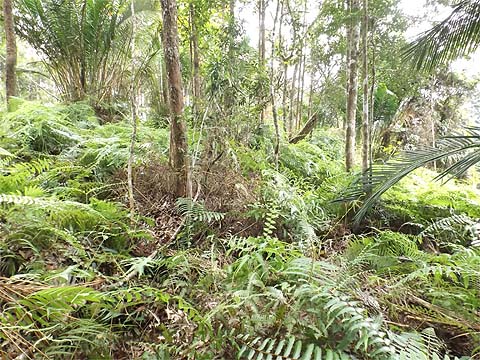
Although my bad knee was aching after the previous long hike, I was optimistic that I could sort out the ridge ahead which had caused me issues previously. In just over 10 minutes I came to the first open area.
The ferns were expected, fortunately I could pass them on the left without going very far below the ridge. By the time I got to the 'normal' ridge, half an hour had elapsed.
The trail is less than distinct, but this boulder is a rare landmark although I passed it on the opposite side today. As expected the ridge dropped slightly and then flattened out. Nothing to worry about yet!
With one hour gone, I recognised where I had rejoined the ridge after getting badly lost for an hour previously. I continued up to an open area, where things started to look promising.
At the top of the rise I went slightly left as indicated by the maps, things still looked promising... Unfortunately, it was a relatively flat area, there were no real landmarks and although I knew I had to turn right soon, the only trail I could see was straight on.
I realised that it would soon go steeply down, so I went back up to where I had been before, fortunately just 20 minutes were wasted. Eventually somehow I located the ridge and ten minutes later I could see ferns ahead. Initially, I thought it was the ferns I had met after the summit of BBF which had been the source of my downfall, but this time I realised later it was indeed actually BBF itself. It was quite a shock! If I had known then I would not have ploughed straight through the middle.
That fact only became apparent when I came across these two distinctive boulders. It was now two hours since I had left RG 18 which I considered not too bad given the environment. I was obviously on my way down and could not resist the temptation to celebrate.
After which the trail was distinct and it was 'business as usual'. The first ferns I passed on the right and the second more substantial ferns on the left, returning to the trail where it passed to the side of the large boulder.
At which point things went completely pear shaped. Firstly I picked one too many fights with the prickly ferns and broke the top off my walking stick. I could live with that but then I could no longer find the route I had come up, I was barely ½ an hour into the descent with more than an hour to go to the water pipes. I had no choice but to try to stick with what appeared to be the main ridge and hope for a happy ending. For ¾ of an hour it was apparently little different from the way I came up.
Then the boulders started. The first two had a tempting gap between them, but then it became serious and the camera was put away. It was a less than pleasant ¾ of an hour when I didn't know for certain whether I had strayed to the left or right.
The fact that I hadn't crossed the water pipes suggested the former. Then I saw this blue sign. Given the size of the pipe then Sungai Tengah is probably the smallest yielding catchment area on the island, it would scarcely keep Yuehong's washing machine going. The pipe went down and through the fence which was a particularly useless part of defending the PBA's property as I could walk round the end of it.
This is the 'other half' of the Fettes Aqueduct in Batu Ferringhi, one of Penang's best kept secrets. This more than made up for what went before, I had long wanted to come here but visitors are normally more than discouraged.
The tunnel entrance is inscribed 1926 - 1929. Of course today was Sunday and security was non-existent - memo to self = "Visit Air Itam Reservoir next Sunday for RG 1" I was about to climb over the gate when I noticed that the two padlocks were not engaged.
That represented another eight hour walk even though it was conveniently accessible for where we live in Penang, I was more than exhausted. I had originally set aside a week to sort BBF out, but two visits have been enough, although I am committed to showing Rexy Prakash round next weekend. My week of freedom is while Yuehong entertains half a dozen old school friends. Of course, once upon a time seven schoolgirls would have represented a schoolboy's dream. These days trying to satisfy just one is more than enough for me.
|