|
Penang Hills and Trails - Bukit Papan from the
West |
|||||||||||||||||||||||||||||||||||||||||||||
|
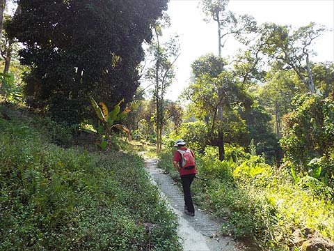
This is one of a series of pages on walking the hills of Penang, click here for the index. This is a Grade 4 walk with very significant less straightforward section. There is a sketch map at the bottom showing the route followed. Please visit my Penang buses page for information on accessing the starting point. Standing in the orchard on the cleared ridge which is the summit of Bukit Papan and looking down towards Teluk Kumbar, you might think that only a madman would attempt to penetrate what looks like extremely steep 'jungle'. On the other hand looking from the hill to the north of the Indian temple, known as Vellaipala Arulmigu Sri Muneeswarar Devasthanam on the Teluk Kumbar to Bukit Genting road we had realised that much of that hillside was actually durian orchards (as normal) and that from the top of the right one, it would not be too far to the ridge. Today's walk was all about identifying the orchard and then confirming the climb was feasible. By 2023 access between the two orchards on Bukit Papan was blocked, it's a shame as it has been a very useful transit in the past. We parked up below the temple which is on a section of the old road now bypassed by a new viaduct - it would be shady on our return. This time we took the path right opposite.
We had turned first right long ago and hadn't got far up, so we went left and the path soon swung right and started to climb,
The main path appeared to go left at the next junction and we soon came to an old house which actually had an electricity supply coming in from the ridge behind.
Loitering inside was a pair of rollers (#90/91), bog standard Leong Chuan, Singapore type, a very useful bonus as they were not anticipated here as we had not seen the power lines.
We continued upward but the path was heading ever nearer the ridge which would have been the orchard boundary. I had no plans to follow it as we were still way below our destination.
We could gauge our height from the new flats in Teluk Kumbar and when the sealed path ended, we turned back.
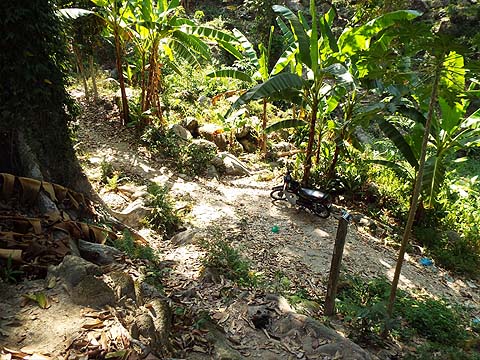
The house had a right turn just before it but I spotted a ruined house just below which needed inspecting. There was nothing left of interest, but below was another path with a parked motorbike. Now this was a different orchard and well worth investigating.
It was climbing in the right direction and above us we could see a hut with more orchard beyond.
There was a migrant couple here and the lady was cooking an early lunch. We were pleased to see that the path continued beyond.
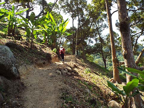
To the right was a new path 'under construction' which we noted as being a possible alternative option. By now the hut was well below us.
We curved right and carried on climbing with the flats now well below us.
When we got a view to the north, it was clear that we were in our desired orchard, that's the ridge leading in the direction of Malihom which we had recently followed.
The concrete finished and we continued on earth which was awaiting surfacing.
Inevitably it finished, I got the impression that this would be a hairpin bend eventually, but for now we just climbed 'freestyle'.
As we neared the top of the orchard, we considered our options carefully. To the left we could go further but my map research suggested the ridge would be higher and further away. I would have liked to check round to the right where the ridge above seemed to be at minimum height but on the way, Madam spotted a gap through the top durians and insisted we try it.
I've learned not to argue so, to maintain her good humour in less than easy conditions, up we went.
We started off in bananas and for a short while, it was still clear.
Suffice to say that the cameras soon went away, I think this was the last clear spot before we had 20 minutes or so finding our separate ways through ginger and other oddments, given our different heights and physiques we have different preferences, but I tend to zig-zag and Yuehong tends to just go straight. Finally, I got to the top orchard first.
Yuehong had chosen to go up a clear area, but it was a near cliff caused by a tree coming down and I had to wait while she sorted out the last couple of metres. After that we quickly got to the ridge.
Here we found the owner's son sitting in the hut staring into space and like all the farmers here, he showed no surprise at our arrival. Yes, we are regular visitors, but we've never come this way before and I'm not sure anyone else has either. We left him to his devices and went round the corner for refreshments. Yuehong checked her 'App', the distance covered was unimpressive not surprisingly but the height gained was quite satisfactory.
The problem with a climb like this through 'virgin country' is that necessarily there is no easy obvious route back to the starting point. If we went south we would have had to cross a very old rubber area down to the Chinese settlement (not one of Yuehong's favourite transits) before going down to Teluk Kumbar from where there is currently no bus service towards Bukit Genting owing to road works. There is no easy route north either, just a steep overgrown descent to the upper Sungai Ara valley. Hence, we had no choice but to go round three sides of Bukit Gambir past the 541 refreshment stall and on down to near Fig Tree Hill Mark 2. Anyone who might contemplate repeating this hike would already be totally familiar with this so the camera went away.
Having earlier scored a couple of rubber rollers when they were thrust in front of me, our next pair required a little bit of brain power. Going down, I had long ago noticed a broken concrete bridge and disused path to the left into old rubber. Now it was time to check it out and indeed less than 50 metres away was a collapsed house with pure gold in the sunshine, all that was left standing. You can read about them on one of the rollers pages, so that was #92 and #93 sorted.
Even in the hills it was a very hot day, and the recently established wide open track to 541 was a sun trap unlike its predecessor. Yuehong wilted to put it mildly, there was almost no breeze even on the western facing slopes as had been the case in the preceding days. The only upturn was spotting this tiny snake which appears to be some kind of keelback, we'd seen several before but all had vanished before the camera was ready.
It was mission accomplished, I was happy with four new rollers and Yuehong's App reported 10km and 500 metres climbed which was much to her liking. However, the day before we had done 12km in the foothills of the Relau hills and for the first time for a while, her right knee showed signs of internal bruising. This indicated a compulsory day off as the day after that was yet another Hakka feast in the hills and not to be missed, it would be our last of the season. In the event, we opted for a rubber roller exploration day, taking the car to the edge of the hills for a series of short explorations. In this respect, it was most successful as the three old houses I targeted turned up a grand total of 10 new ones, including one made by the Cherry Tree Manufacturing Co Ltd of Blackburn, England which survives today making laundry equipment - after all these rollers are obviously related to mangles. I have my century and for the last two weeks we can concentrate on the hiking...
|