|
Penang Hills and Trails - Tua Pek Kong Still Rules
OK? |
|||||||||||||||||||||||||||||||||||||||||||||||||||||
|
This is one of a series of pages on walking the hills of
Penang, click here
for the index. This is a Grade 4 walk unsuitable for those without
experience of off-piste hiking. There is a
sketch map at the bottom showing the route followed. Click here
for a list of the known PBA rain gauges.
IMPORTANT By December 2023, the route from the Bayview Beach Hotel towards the Batu Ferringhi Reservoir past the 'Chin Farm' had been aggressively blocked by razor wire in the area where there is a gate by the water tank. There are also numerous signs stating "NO TRESPASSING - NOT A PUBLIC HIKING TRAIL" This will mean that there is no longer any access to / from any of these well known paths: 1. That to the Rimba at Teluk Bahang I do not know about current access through the main gate to the aqueduct above the former Holiday Inn. BBF is a tough nut to crack, there are reports of my five previous hikes here accessible through the North of the Island index. For the purpose of today's hike the most relevant is the west to east after which I declared I would not attempt it again, it being challenging in the extreme to follow the optimal ridge downwards from the summit. So why did we do it? Simply, I reluctantly decided to use a GPS application which would also allow us to match our route with our most recent transit from east to west. It had rained overnight and looking out across the sea to the mainland, it was more than grey at dawn. Conscious that we hadn't recently changed his oranges, I consulted Tua Pek Kong on the subject of plastic raincoats. Inscrutable as ever, we packed them as an insurance policy, thereby guaranteeing us a perfect day's weather for hiking.
I took Yuehong's advice, we drove Mavis to the Bayview Beach Hotel for an early start on the basis that if the worst came to the worst we could effect a recovery after dark. As a result we were able to start at 07.40. The light was grim and after we entered the forest, a torch would have been handy. I have not reported the climb to rain gauge 18 in detail as I did this quite recently - click here for that report, there is a link in it to return here afterwards.
It's a pretty painless climb as such things go, but it does involve nearly 1½ hours of relentless grind. Compared to going via Bukit Cempedak (rain gauge 17, RG 17) there's a time saving of about half an hour. By the time we hit the rain gauge trail the sun was out but unlike recent weeks, it was not hot, in fact hiking conditions were about as good as it gets, Tua Pek Kong had done us proud (again) and the unnecessary raincoats weighed a lot less than my refreshing liquid.
The junction is near a minor peak and going down from it there's just this minor obstruction to skirt, at this point we noticed some shredded paper, it seems one of the hashes had been along here. We'd been going 2½ hours which compared well with what used to take us over 3 hours.
I parked the essentials out of reach of the ants and we took a 15 minute break, I was not surprised to see that the paper continued in the direction of RG 19 and, of course, we turned left for BBF.
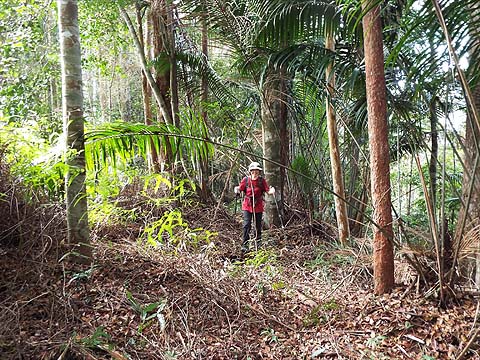
It hardly counts as a path but there is a more or less clear route along the ridge which winds around what are rarely more than minor obstructions.
I've been along here often enough to have a list of landmarks, the first being an open area which has resisted the ferns which have sprawled across the ridge shortly after.
Fortunately, there's just enough of a gap between them and the sharp drop on the other side.
More trees and then we came to the huge boulder which looks completely out of place perched on the ridge.
There is just one point where the 'trail' becomes indistinct as there is a large tree down. All that is needed though is to keep near to the ridge and after the col, there is a clear route up through an open area.
About here, I had a minor brain fart and managed to turn left instead of right, something I had done last time too, it won't happen again, that's the right direction behind Yuehong! It wasn't quite noon as we approached the ferns which mark the summit of BBF, which meant we were spot on my outline schedule despite the diversion.
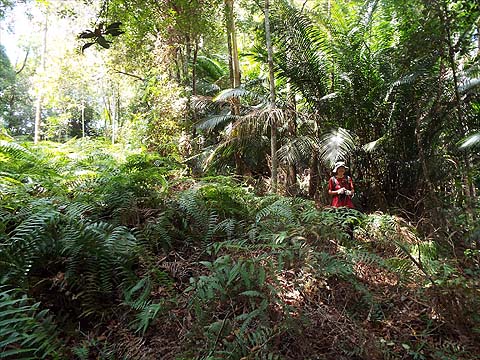
The trail turns left and climbs gently to the edge of the ferns where they part like the Red Sea, it's a long, long way to go round them.
On the other side, the hilltop quickly narrows into a ridge and we made our second planned break at a small boulder. This was the point at which the challenge would start in earnest.
There's a second bigger boulder to pass and the descent starts deceptively easily on a distinct ridge trail.
This obstruction was familiar from our recent westbound transit, there was no point in wasting time looking for a way round, it had to be scaled.
Next up was the first fern patch, which going down has to be skirted to the left and then we got back on the trail.
The second one is rather bigger and needs the same avoiding tactic.
Confirmation that we were retracing our steps successfully came with yet another landmark boulder but in skirting the obstruction next to it we went too far right and found the next patch of ferns ahead of us. We had to go back up and then keep left.
As the ferns ended, there was a mirage ahead, a clear area apparently. We didn't go very far down before the sight of the condos near the Floating Mosque brought it home to me that this is where I had gone disastrously wrong last time around. This was time to 'phone a friend' and out came the 'App' which showed we were just a few degrees off course. What the map fails to show is that the ridge actually splits here and we needed the right fork and not the left (this one). Back up we went a short way and then across the bottom of the ferns.
It was hard to accept that we needed the more overgrown route but the trail was just about visible and we stopped at an open area for confirmation - there's what looks almost a ditch running down behind Yuehong.
Following the trail exactly is probably impossible but at least we knew to keep close to it. At one stage, we clambered over a couple of fallen trees. Sometime later we hit hash paper.
For a short while it followed the trail but then went right. Conscious that the next section to the pipeline had been very overgrown a month earlier we opted for the hash version of the descent. It wasn't pretty but it did the job and got us to the pipeline. Although we didn't recognise where we were, left was the only choice as that side should have been the trail and also the pump house if we had miscalculated.
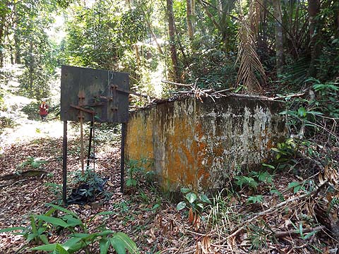
We soon passed this tank and strange contraption, that's Yuehong catching up in the background. Then almost immediately, we came to our landmark pile of spare pipes.
This heralded our third, and final, extended break. Yuehong's knees were grumbling, the reason was unusual to say the least. In the last month of dry weather many leaves have come down and today ever since we left the formal paths we had been walking on several inches of soft leaves, so every step had carried with it a degree of destabilising uncertainty which did them no good at all. While I always seem to end up at the pile of pipes, there is no fixed route over this next section and after a long day, I decided no purpose would be served by trying to record it.
It's steep and we wiggled and wriggled as we tried to avoid the boulders and areas with fallen trees, Yuehong wisely took a break mid way. Finally, I could see the Sungai Kelian valley path below, but Yuehong was almost on it before she realised, such was her concentration needed to make progress. Once on it, her body language showed the result of all that effort..
However, after barely 100 metres she recognised our usual route up and she perked up immediately. That meant we were no distance from the PBA Pump House area and very soon we were at the Indian temple on Jalan Lembah Permai.
It had taken some 4 hours to come down from the summit of BBF which meant that even with help of Yuehong's 'App' we had still managed to spend an hour longer than our last 'normal' passage. However, we had demonstrated that the descent was feasible and probably based on what we had discovered, reproducible although we have no plans to test that. There was more than enough daylight to spare and we took the 102 bus to pick up Mavis after which I had a couple more celebratory Tigers while Yuehong went for a swim as therapy for her knee. After dinner, she vanished straight to bed and I started work on this report. This hike was originally meant to be #100 for the visit, for various reasons it became #98. I can't believe that anyone who hikes over BBF does not have a rest day afterwards. We'll need a short walk to check her knees have recovered before we decide whether our revised plans for an even tougher one planned for #100 over the weekend are sensible or not...
|