|
Penang Hills and Trails - Tiger Hill Ridge
Circuit |
|||||||||||||||||||||||||||||||||||||||||||||||||||||||||||||||||||||
|
This is one of a series of pages on walking the hills of Penang, click here for the index. This is a long Grade 3 walk. There is a sketch map at the bottom showing the route followed. Click here for a list of the known PBA rain gauges. Please visit my Penang buses page for information on accessing the starting point. This account is linked from my Penang Peaks page which lists peaks over 400 metres as well as other places of interest and viewpoints. To find other hikes which visit this peak please check the maps of this are using this link. The peak referred to is actually the 'old' Rain Gauge 29 position. We've been in Penang for just under 8 weeks and it's a measure of how often we have been out that this was our 50th hike. There's not been a great deal new, hence the lack of reports but today to celebrate and work off the excesses of recent dining opportunities, I had arranged something more challenging. I did not take any new photographs on the main ascent past Rain Gauge 28 up to the site of Rain Gauge 29 (RG 28 / 29), not a great deal has changed. This time, the path was a little clearer as some of the fallen debris had rotted down and there was just one new significant tree fall. Instead I have used the first section of our report from March 2019 when we turned left at the top, this time we would turn right. You can skip to that point by clicking here. Quite recently, the PBA has placed two rain gauges next to the dam car park. One is traditional and one the current version. They have no numbers and as the box is locked I don't know whether it is functional or simply represents a very good public relations exercise as there is already a perfectly good one (RG 35) on the other side of the dam. The fact that it has an overflow pipe (unlike all the others) suggests the latter. The old style one is clearly a very new 'replica'.
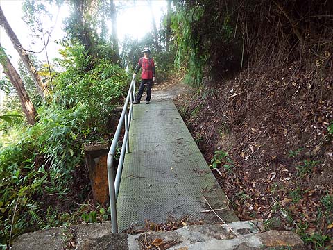
We walked across the dam and up the side of the work area to join the wide path out to the right. It's a good way to warm up, it follows the contours and there's one junction where we kept left. Soon we reached the concrete road that comes up from the Buddhist temple by Kek Lok Si, "KWARN INN SAHN POW YIN SIAN TSI(P)" - if you don't have a car this is the way to join the walk.
It's not very far up to the start of the main climb, it's behind Yuehong opposite this distinctive junction and the short, first part is very steep.
There is (was) a short cut from part way up the concrete road to where rain gauge 28 (RG 28) has been relocated but it seems to be rather overgrown. The initial part of the climb is through former rubber but apart from the outlines of terraces there is no real indication of this.
One terrace is rather clearer than most and this is the former location of RG 28 as evidenced by the 2016 picture on the right - note the two larger trees with the thinner one behind.
Above the rubber, the 'forest' was clear as quite a few trees had come down.
It was a relief to get back under the canopy and we could see that we were back in the 'rubber'.
Again, as the rubber finished we entered an area of carnage. the hill behind our condo is similar above the transition and I don't think this is just a coincidence.
Never mind, as we continued to climb we seemed to be in original rain forest.
The last time we saw 'F3' was on the descent to Pantai Mas, I assume they are some kind of hiking group. By now we were about half way up and had reached the first of three minor peaks. That's a 'Moniot stone' in the foreground, a survey marker.
After the briefest of descents, we started to climb again.
The second and third summits came and went, by now it was markedly cooler and more pleasant.
We reached the ridge and I found that the original RG 29 was still present, last year (left) it had been buried in the ferns.
Three years ago the path to the right appeared neglected, today there were markers galore as we set off and later some totally redundant red and white tape (probably courtesy of UTOP).
Most of the old signs have vanished but this one was left at what had once been the junction fro the path directly to Tiger Hill, now, alas effectively defunct. Never mind today's path which skirts it was a delight and in good condition.
One new colour was this yellow / orange unless one of the other groups has found an alternative paint supplier. We were now zig zagging downhill to join the path from the Air Itam Dam that sets off from near the Sitavana Vihara.
When we got to the junction we found the last remaining sign unloved on the ground and the path unloved too - not surprising as we had scrapped plans to use it when we saw the other end recently. Peter van der Lans says it is 'passable with difficulty' - I'll take his word for it.
We continued towards Moniot Road and were halted by the red and white plastic and some green string. We had heard about this diversion and headed upwards a short way to a ridge where we turned right.
We now had a steep descent back to the original path.
At the bottom there was more plastic and I went along to see what the problem was and very soon I was confronted by a substantial landslide no doubt a result of the November 2017 Great Storm.
We got to Moniot Road and turned right, UTOP had obviously been this way but they had left fewer of their markers than they had in the Pantai Acheh area which we had found festoooned.
Through the trees we could see the extent of the landslide, it looks to still be unstable so I guess the path won't be reinstated any time soon.
Moniot Road is perhaps the most delightful of Penang Hill's minor roads and we emerged behind Mon Sejour which we had visited recently.
The dangerous wooden bridge had been replaced and a small landslide had a reinstated path.
We joined the road down from Summit Road and Yuehong emptied her shoes. We turned right to follow the sign to the Brothers' Bungalow.
At the third sign we normally turn left but today we stayed on the road, ignored the 'trespass notice' and went left just before the road finished.
This brought us to the servant's quarters where we did a U turn and continued down. I'm a sucker for checking out paths but this one on the right was a disappointment leading only to a 'flower garden'.
This route is very 'knee friendly' compared to most on the hill and Yuehong was striding along as we rejoined the other route.
We stuck to the main path and were greeted with a fine view out - well it's fine if you like urban sprawl and it was a clearer than average day.
Just below the small temple we took this critical turn to the right, carrying on would have landed us in Air Itam (with a car at the dam). You'll know you are on the correct route if you pass this old house.
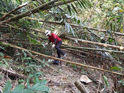
Next we came to another critical junction. The path to the right is a dead end - another flower garden. We needed to keep left and immediately that meant negotiating these fallen bamboo stems.
No problem and next we had to face the main reason the path was no longer well used. This small landslide was just a bit overgrown.
Then the path improved and was well lit in the afternoon sunlight. Paradoxically, the second larger landslide was easier to negotiate.
More sunlit hiking and then another junction where we would continue upwards and not turn left as we used to.
This quickly brought us into a fruit orchard where we kept straight on and down slightly.
The path then climbed and in no time we were at the house on the road up to the Sitavana Vihara.
We were now on the home stretch and returned to the dam. We'd been out slightly more than 6 hours and covered some 15km. Lots of calories had been burned no doubt but the bathroom scales didn't reflect this...
|