|
Penang Hills and Trails - Above Nibbinda |
|||||||||||||||||||||||||||
|
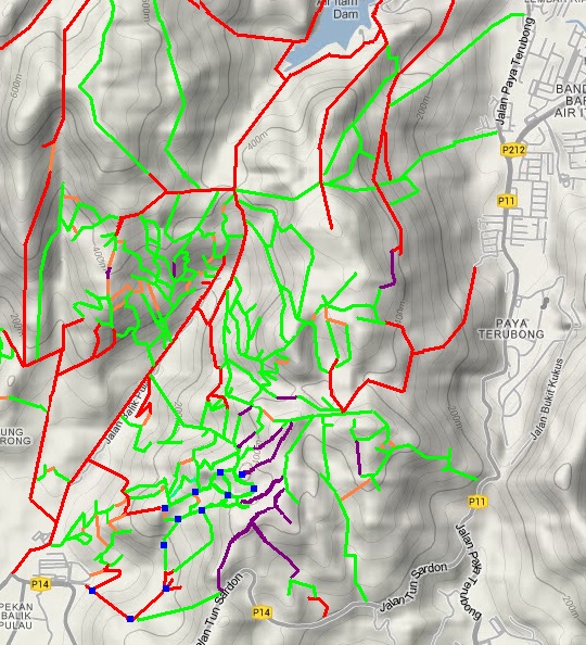
This is one of a series of pages on walking the hills of Penang, click here for the index. This is a Grade 2 walk with a short Grade 3 section. There are two maps at the bottom showing the route followed. Please visit my Penang buses page for information on accessing the starting point. It's October 2022 and after a break of 30 months for obvious reasons, we are back in Penang. We're on the way to regaining full fitness but have yet to do anything adventurous together. I will need to annotate some earlier walks with major changes, but this is the first time I have needed a brand new page. 3 years ago, the area above Nibbinda was covered in rubber, the top part abandoned. Now it has all gone and is being steadily replaced with durians which for the time being are interplanted with bananas which is standard local practice. This is an environmentally sensitive area as it runs up to the edge of the Bukit Relau Permanent Forest Reserve. The boundary on the other side of the ridge has become notorious for being attacked by overenthusiastic vegetable farmers although when we took a look a couple of weeks ago. all cultivation had effectively ceased. I doubt it was a death bed conversion, more likely it was the result of the exodus of (often illegal) foreign workers. I assume from the sign in the first picture that the estate owner here has had an official inspection carried out. That's 50,000 square metres or 12 acres in 'old money'... On arrival in Penang we had been given the same Myvi ('Mavis') which we had used when we first started hiring a car, but now it was needed back for another customer and for the last week of this stay we had been honoured with a Honda City, a classic free upgrade. It's a lovely car, no doubt about it, but totally unsuitable for the round-the-island 'ghat' section and small estate roads. Click on the thumbnail for a larger version of the thumbnail and lick on that to return here.
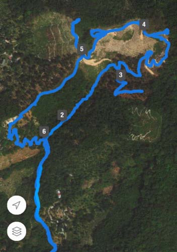
It's some 6 years since we first used the road that starts off from Jalan Tun Sardon leaving Balik Pulau just after the bus station. It quickly leaves the coastal plain behind, it's around 50% shaded just as well as it had turned distinctly warm. Early on there's a splendid view up to the hill on which Nibbinda is situated. We have recently been assured that there is a viable route from the area of the Santarama Buddhist Retreat, it would be rather steep and for the time being we're sticking to the less strenuous alternatives. We just had to follow the electricity supply although the correct route is quite obvious. Our destination today was the cleared area in the V just to the right of Nibbinda.
Eventually, at the last modern house, the road turns into a concrete path which soon comes to a junction with a bridge over a stream on the left ('6' on the map at the end). This was our traditional access to the monastery but there was no need to go up there today. We had checked it a few days earlier and, with care, it was quite easy to reach one of the bungalows and from there continue up. Our usual route using the durian orchard just east of the main buildings is currently very overgrown.
Today we carried on up the main path and soon we came to the first of the recently cleared areas. The gate was wide open and immediately after we turned left across the stream on what appeared to be a new path. We had been up the original path some time ago, it went high up the hill where today even more clearance (also below the Bukit Relau Reserve I assume) is occurring
We had come in from the left a few days ago but we wanted to see what happened in the valley we were following. Eventually we could look across (from '3' on the map at the end) at completely new path which has been cut slicing through the former rubber. The bananas are obvious but in between are already thriving young durians.
Just to be sure we continued back across the stream and rejoined what was either the main path or a branch off it at this hut. In fact we went quite a way up until we could be certain there was no easy way to cross the stream back, maybe it would have been practical in 'the season'. So we returned to the hut and turned right retracing our steps to this junction. To the left is the way we had come up today and on the middle is the new route down described above which we knew all about So we took the path on the right which is not new, through mature durians.
We ignored the path left at a junction and wound our way upwards until we entered the newly cleared area, so both these views are looking north.
We were on a mixture of yet to be sealed wide tracks and concrete paths with views south towards the Pulau Betong area, they got better the higher we went - necessarily you won't find any pictures like this in our archives. The first picture was taken from the open area on the left of the second, the access path can be seen coming up. Nibbinda is visible on the right and the blue hut is directly connected to it along the ridge.
The first picture includes about 25% of the second one above and we had wound our way up the Bukit Relau Reserve / estate interface. As we made the final climb we were next to a line of young rubber trees which were planted during the early days of our explorations nearly 10 years ago. That side had well established paths but from outside, it's not clear what has happened to them, I am sure that it will not be difficult to find out by coming up them, starting from the Balik Pulau - Air Itam road.
This shows the clear break between the jungle and the new estate, over the next few years it will 'soften' no doubt. The picture on the right shows the way into the Bukit Relau Reserve. The old sign has vanished, no doubt as a souvenir, and one innovation was the inevitable plastic markers which so called 'green' hikers find it necessary to erect as they seem to have the memory of a goldfish despite access to GPS systems, (this place is the apparent blob to the right of '4' on the map at the end)
That was essentially the end of today's exploration. I couldn't resist a picture looking across to the Temple with the View (Ngoh Hean) with Bukit Elvira above (from '4' on the map at the end) . The second picture shows the descent from the two pictures above. Yuehong is standing on the wide track ('5' on the map at the end) which leads down to Nibbinda which is currently 'closed'. We were assured on our first hike here that the monks will return 'very soon'.
So down we went, it was deserted as it had been a few days ago and we were free to wander as we liked. Walking towards the main complex, we knew to take this track to the left, the abandoned white car is an easy landmark. We continued down to the left of the first house from where a concrete path ran off. Very soon we came to a junction. We knew not to continue straight on, but took a sharp left back down the hill.
Intuitive it is not, but we had previously come up this way. The steps to this 'hut' lead off directly from the path and below it is what I would call 'mixed vegetation', old rubber (left) and durians (right). It doesn't look very promising, but I knew that less than 50 metres below was a path left onto an old rubber terrace. We took this and very soon we could see the end of a concrete path with informal steps leading down to it. That had taken just a few minutes from the hut and now we carried on down to the T junction we had passed a couple of hours earlier. It was very warm and we were down to the last of our water supply as we headed for the car. We are conservative in our eating habits and since it was a Wednesday and our Sungai Pinang restaurant closed we went back home for a shower (and a swim for Yuehong) before dinner.
It's hardly a 'thing of beauty' at the moment but the new views made the visit worthwhile and reestablishing the connections with the upper end (first report and second report) of the valley will offer an excuse to return some time soon. All in all very different from our first visit all those years ago. In 5 years time it should look nothing like so unpleasant and in 10 years there's no reason to suppose that it will not be a very attractive area to walk through - unless the durian price totally collapses! I have tried to redraw my original map of this area to include the changes described above but not all new paths are shown. The numbers on the GPS trace represents kilometres covered but I have used them as if they were labels in the main description above. In practice, for the time being, the area at the top is so open that it's easy to see where the paths are for the most part. |